
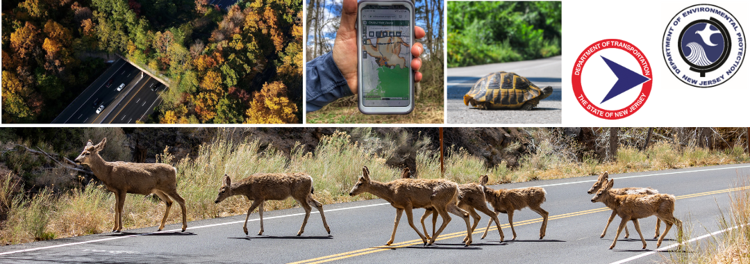
Wildlife crossings help to bridge greenspaces divided by roads, streets, and highways through the creation of safe alternative pathways for wildlife. For the past forty years, wildlife crossings have been a part of New Jersey’s transportation network. The state’s first known crossing, a terrestrial overpass, was created during construction of Interstate 78. Since that time, the number of wildlife crossings has increased, and continues to do so with the support of the New Jersey Department of Transportation (NJDOT) and the New Jersey Department of Environmental Protection (NJDEP).
With myriad benefits for both nature and humans, wildlife crossings establish essential connections within a sustainable, resilient, and safe ground transportation network. To learn more about NJDOT and NJDEP’s effort to increase and improve wildlife crossings in New Jersey, we spoke with several staff members during a group interview.
From NJDOT:
- Domenica Mousa, Environmental Specialist, North Environmental Team, Office of Landscape Architecture and Environmental Solutions
- Rachel Dekovitch, Supervisor, North Environmental Team, Office of Landscape Architecture and Environmental Solutions
- Amber Cheney, Section Chief, North Environmental Teams, Office of Landscape Architecture and Environmental Solutions
From NJDEP Fish and Wildlife, Endangered & Nongame Species Program:
- Gretchen Fowles, GIS specialist and wildlife biologist, , Co-lead of Connecting Habitat Across New Jersey (CHANJ)
- Brian Zarate, wildlife biologist, CHANJ Co-lead
- Mackenzie Hall, wildlife biologist, CHANJ Co-lead
The following Q&A is a summary of the conversation which has been condensed and edited for clarity.
Q. It is estimated that there are over one million annual wildlife vehicle collisions nationwide involving large wildlife. The need for, and related benefits from, wildlife crossings vary but can include benefits to both human safety and wildlife survival, as well as cost savings. What other potential benefits come to mind when you think of roadway wildlife crossings?
NJDOT: New Jersey is a densely populated state with an intricate network of roadways, often cutting between greenspaces. These greenspaces, including forests, fields and streams are home to a variety of species, many of which travel and explore. Unfortunately, these two realities cause a significant amount of traffic collisions; the most serious of which are caused by deer. These collisions can be very unsafe for drivers, passengers, and wildlife. Fortunately, wildlife crossings can be implemented to keep fauna away from the roadway. The result? Safer drivers, passengers, and wildlife.
NJDEP: From the Department of Environmental Protection’s perspective, wildlife crossings provide important environmental benefits in addition to reducing wildlife fatalities. The division of greenspaces by roads and highways is considered habitat fragmentation. Habitat fragmentation worsens the conditions of endangered species, affects ecosystem function, and reduces the ecosystem’s resiliency. In short, it keeps species from moving, mating, and finding food. The implementation of wildlife crossings helps to reduce habitat fragmentation and improve connectivity. Often this improved connectivity creates healthy ecosystems where populations can behave and survive naturally and move about as they wish. Connectivity also contributes to the maintenance or restoration of ecosystem function and ensures rare species have a chance to recover. Even non-rare species can help maintain their health and population with improved connectivity. The NJDEP team wants to build all these redundancies into the ecosystem to allow the more imperiled species to have opportunity to recover, while also maintaining populations of existing species that are seemingly doing well.
Q. Many New Jersey highways and roadways fragment wildlife habitats and challenge migratory paths. With one of the densest road networks in the country, how does your department address concerns of biodiversity and habitat connectivity within the context of road and bridge development?
NJDOT: Each bridge or road project goes through an environmental review to identify any environmental issues or constraints within that project area. As a part of the analysis, we screen for federally and state-listed threatened or endangered species. If such species are found, restrictions or guidelines are specified. For example, if the proposed area has birds that are listed under the Migratory Bird Treaty Act, or has endangered or threatened bats, we put a time restriction on when tree clearing may take place. These efforts help to preserve the habitat by limiting tree cutting to periods when animals are less present, typically from November 16h to March 31st.
The NJDOT Office of Landscape Architecture (OLA) started a Pollinator Program in 2020 to help promote biodiverse connectivity throughout the State along our appropriate right of way while considering alternate mowing opportunities. Our Capital Program projects seek to enhance the native species of the specific location, and we use our Pollinator Program to supplement and create more locations. Each year OLA applies for funding through State funds for these plantings. Many times, these locations are chosen based on the best management practices (BMP) of the Maintenance yards that reach out to us for consideration of locations. These created sites help offset and maintain assurances of our Department’s compliance with the Endangered Species Act.
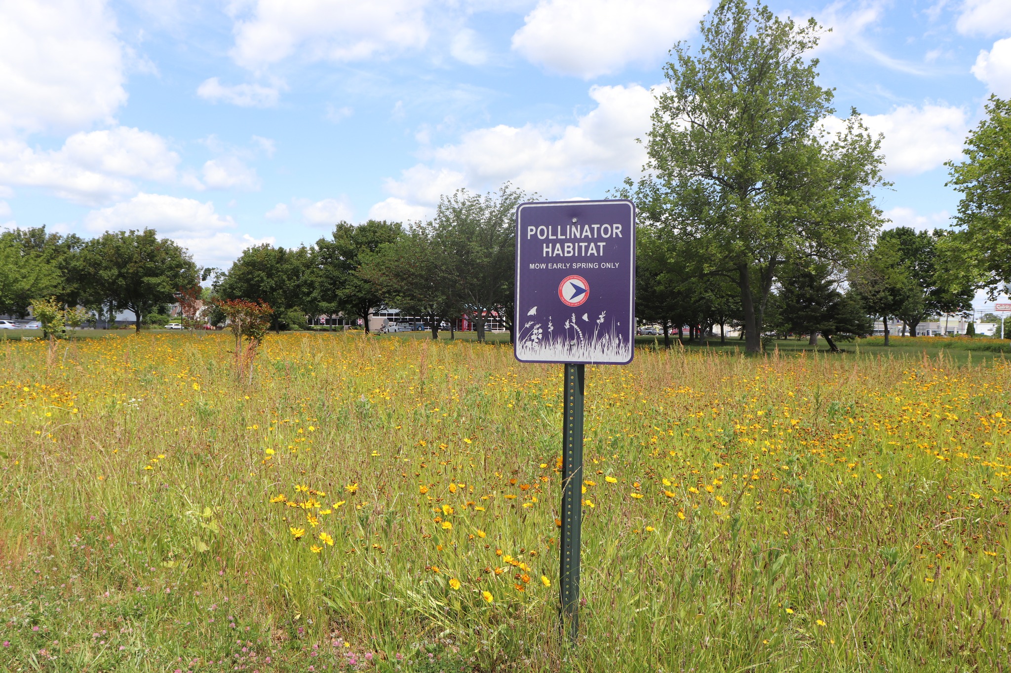
In 2023 we became more proactive in establishing habitat for the Monarch Butterfly and created the 100,000 Milkweed Initiative. With the funding set aside for pollinators we planted over 100,000 of 3 types of Milkweed species throughout the State. To date we have created over 11 Acres of Milkweed Specific habitat and over 40 Acres of additional Pollinator and reduced mowing areas through the Pollinator Program. NJDOT Lands are significant in creating a linear and ideal habitat for Pollinator activities which is also why we address Pollinator Habitat through Capital Program Projects.
Q. In a recent “Lunch and Learn” presentation, it was noted that changes to the NJ Flood Hazard Control Act Regulations require that NJDOT evaluate new and existing bridges, culverts, or roadways for fragmentation of habitat for threatened and endangered and/or any species of special concern and provide a wildlife species passage if a project is determined to cause fragmentation of habitat. How has this requirement affected your work program? Has this change heightened interest in wildlife connectivity?
NJDEP: The NJDEP Flood Hazard Area Act regulation has led to a significant increase in the number of permitted and implemented terrestrial wildlife crossings. It has also fostered more projects and collaborations across NJDOT, other NJDEP divisions, as well as with counties and municipalities, and non-profit organizations.
However, the regulation can sometimes create challenges. For example, while habitat fragmentation might be occurring, the feasibility of installing a wildlife crossing might be difficult because of other infrastructure in the area or the stream’s hydrology. In such cases, NJDEP and NJDOT work together to determine the best course of action.
Q. As noted, this topic is of interest nationwide. The FHWA Wildlife Crossing Pilot Program (WCPP) has $350 million in federal aid funding available through 2026 for state DOTs and others. FHWA plans to release the next NOFO shortly. Has NJDOT considered pursuing one of these grants for a construction or non-construction wildlife corridor project?
NJDOT has pursued this competitive grant, unsuccessfully. The FHWA grant focuses on human and driver safety and projects where large mammal collisions are occurring, making projects for smaller wildlife species, less likely to be awarded a grant, and most of our projects focus on smaller animals. Losing smaller animals poses a risk to the health of the ecosystem, and future justifications will consider this.
The Wildlife Crossings Pilot Program grant is just one of many options within the Bipartisan Infrastructure Law, which offers historic support to tackle habitat fragmentation and wildlife mortality. Other opportunities within the law may be more helpful to pursue, such as eligible formula allocations, rather than competitive grants. That said, NJDEP Fish and Wildlife successfully applied for a Transportation Alternatives Program grant that is resulting in the construction of an amphibian crossing in northern New Jersey, but it took ten years of work to get to this stage. The crossing has not yet been constructed but anticipated in the next year or so.
Q. Can you tell us a little bit about the North Atlantic Aquatic Connectivity Collaborative? How does NJDOT participate with NAAAC?
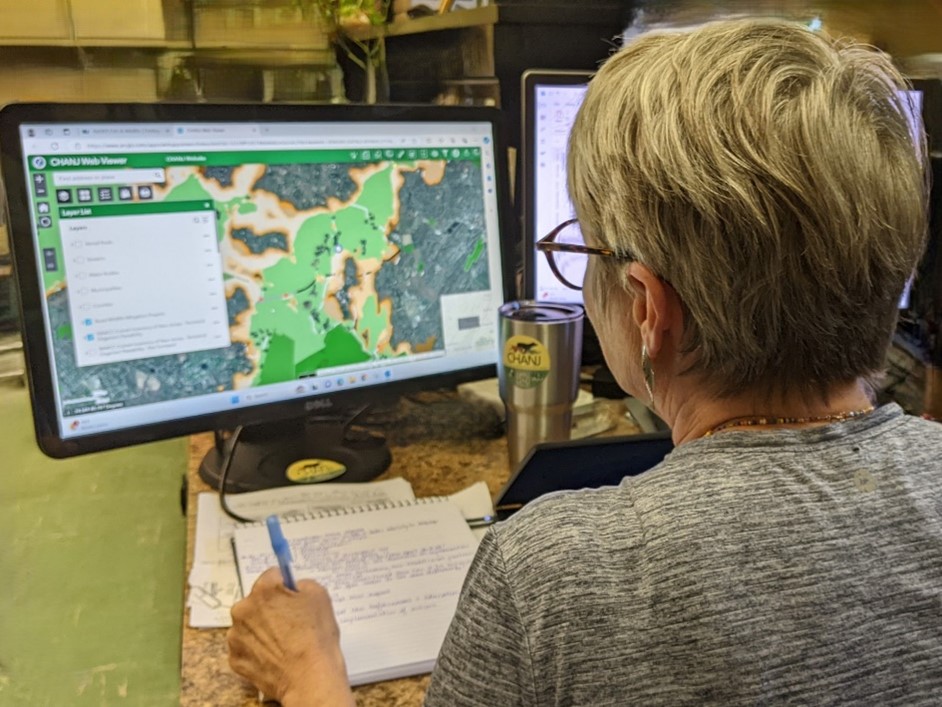
We are participating with the North Atlantic Aquatic Connectivity Collaborative (NAAAC) program to survey current culverts and bridges and evaluate possible wildlife passages. Once surveyed, this information becomes available on the Connecting Habitat Across New Jersey (CHANJ) online mapping tools and via online or downloadable GIS services. The use of these maps can help to identify when there is an existing barrier for terrestrial or aquatic species. We also use other GIS layers, such as the NJDEP Landscape Project and CHANJ, that is also included on the map to determine if there are any terrestrial species of concern and suitable habitat on either side of the culvert/bridge or in the area. For each project that requires an NJDEP Flood Hazard Area permit and involves a bridge or a culvert, we use this map to write up a brief analysis, which we then send to NJDEP.
Q. According to research, the evaluation and development of road crossing projects are mostly being led by several organizations including the NJ Department of Environmental Protection, North Atlantic Aquatic Connectivity Network, and other localized, environmentally-focused organizations. What role does NJDOT have with these organizations and projects?
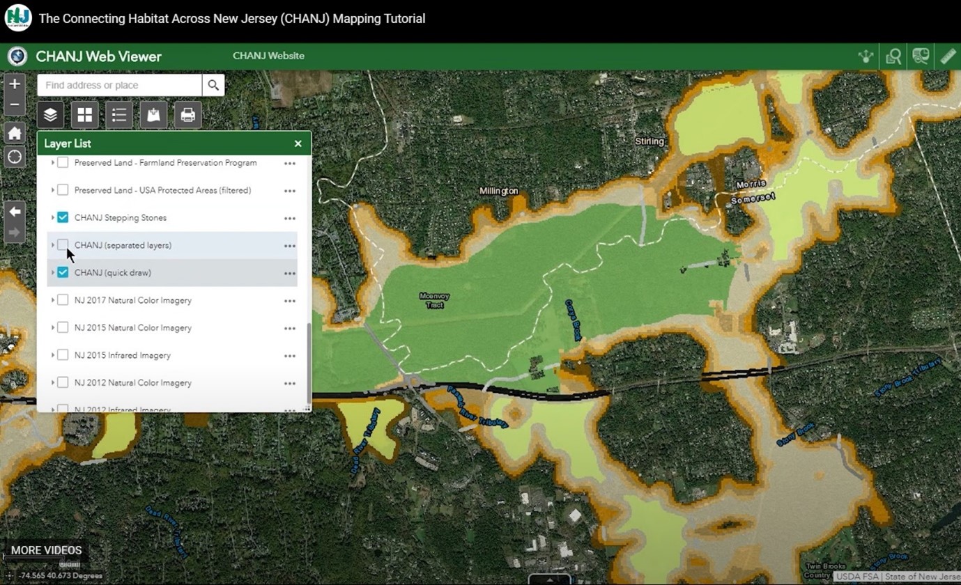
NJDOT works with NJDEP to prioritize and list culvert and/or bridge sites that need to be surveyed for NAACC. This year, NJDOT employees will join in the analysis, conducting site surveys to enhance the online dataset for future projects that may require crossings. By collaborating with NJDEP Fish and Wildlife and various watershed groups across the state, NJDOT and its NAACC partners have assessed about 700 culverts so far. Each has been mapped on the CHANJ web tool, which identifies wildlife habitats, cores, and the corridors that connect them.
NJDEP and NJDOT use the CHANJ mapping tool and NAACC generated layers to understand connectivity for both land use and transportation projects, including NJDOT projects.
“By collaborating with NJDEP Fish and Wildlife and various watershed groups across the state, NJDOT and its NAACC partners have assessed about 700 culverts so far.”
Regulatory officials evaluate the map when assessing Flood Hazard Area permits. The map also helps provide a general sense of connectivity within the state, aiding in targeting areas for road improvements, land acquisition, and habitat restoration. These actions are crucial for creating a functionally connected network of land. The CHANJ mapping of habitat cores and corridors, along with all NAACC culvert data, help prioritize sites.
NAACC culvert analysis is often conducted by trained watershed groups and NJDEP Fish and Wildlife seasonal employees. Montclair State University serves as the state lead and coordinator, offering training for interested parties. Free training and resources are also available online from the University of Massachusetts.
The NAACC collaboration spans 13 states in the Northeast region. The NJ NAACC map allows users to select squares on the map (which indicate a culvert) in order to access the regional database. Once the user is redirected to the regional database, they are able to access the corresponding pictures of the culvert, if it has been surveyed, as well as the culvert’s dimensions. This innovation helps users understand what lies under specific road stretches simply by the click of a mouse.
Q. The Connectivity Habitat Across New Jersey (CHANJ) interactive mapping tool catalogues current and completed projects, the passability of road culverts for aquatic and terrestrial species and other details. This map is partly a product of the NAACC 13 state map that aims to compile wildlife connectivity information into one database, and relies on culvert assessments using the NAACC culvert inventory. The map does not include information about roadkill or auto collisions with wildlife, which limits the basis on which a project could be installed. Are there plans or current processes to collect data on wildlife collisions and roadkill?
NJDOT maintains crash records based on police reports that may refer to wildlife collision. However, NJDOT does not currently collect any data regarding roadkill. NJDEP Fish and Wildlife collects roadkill location data, but only for select species like bobcats, bears, coyotes, otters, and beavers. Those data are combined into a roadkill dataset. For some species, like the state listed bobcat, biologists collect the carcass, and sample it to glean as much information as possible that contributes to their understanding of the health of the population.
Q. Maine Audubon worked with Maine DOT and UC Davis Road Ecology Center to build a crowdsourcing tool that drivers could use to report the location of roadkill. Is NJDOT currently using any type of crowdsourcing in this way? Are there plans to record more information about roadkill and collisions?
The new NJ Wildlife Tracker tool expands NJDEP’s data by collecting resident reports of rare species sightings and observations. For instance, someone can report seeing a turtle by a stream using this mobile-friendly web application. Reporting is also open to all species, rare or not, that are on roads. This tool aims to increase awareness of roadkill, and to help identify roadkill ‘hot spots.’
The NJ Wildlife Tracker and NJ Fish and Wildlife data mining help identify road mortality hotspots. Between the two we currently have around 7,000 roadkill records in our database. We are developing a standardized roadkill collection tool, where individuals monitor important road segments bisecting habitat cores and corridors identified by the CHANJ map and report wildlife sightings. Regular commuters can report on specific road segments, providing detailed data for rigorous hotspot studies.
This data is useful for pursuing grants or projects. For example, the upcoming Waterloo Road Amphibian Crossing Project in Byram Township, Sussex County, was justified by years of collected data.
Beyond data collection, we use other tools to interpret and analyze findings. Animal data points require careful interpretation due to their constant movement. One key tool is the NJDEP Landscape Project mapping, which uses wildlife observation location data to infer valuable habitats.
However, there are concerns about crowdsourcing and public data access, particularly regarding the illegal wildlife trade. Detailed mapping tools can be exploited by poachers. At this time, this information is only accessible by NJDEP.
Q. Are there any technologies that have been useful in designing and modifying infrastructure to better suit wildlife?
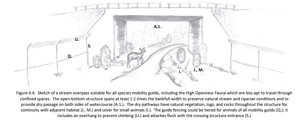
Sometimes simple modifications to infrastructure can ensure effective wildlife crossings. For instance, adding a ledge to a culvert can allow animals who avoid water to cross. Bobcats are one species that benefit from this inclusion. The ledge is ideally a natural stream bank within the bridge or culvert, but can also be constructed of concrete or gravel, and can be tailored to the species present and their needs. All design modifications require hydrology and hydraulics analysis to determine if the modification is feasible.
Through CHANJ, there are two main tools: a map and a guidance document. The guidance document includes best management practices for designing wildlife passages across different taxa. While not high-tech, these practices significantly improve the effectiveness of crossings.
Q. The NJ Pilot Road/Stream Crossing Assessment focuses on culverts to improve connectivity for aquatic wildlife; however, NJ is also home to terrestrial wildlife that require special crossings. How do you approach this divide in your work, and what are some ways that transportation agencies can design passages that are suitable for both terrestrial and aquatic wildlife?
Designing wildlife crossings can be complex, especially when dealing with driveways and land use constraints. Studies have shown that incorporating effective fencing is crucial for directing animals towards crossings and preventing wildlife from accessing the roadway. Innovative designs include using flexible recycled plastic fencing directly attached to structures, which helps prevent animals from breaching gaps. Some designs feature a protective lip to deter animals from climbing over.
Advancements in monitoring technology, such as infrared cameras, are proving invaluable. NJDOT is initiating a project to monitor several highway underpasses not originally designed for wildlife but identified as potential crossings. Infrared motion detection captures warm-blooded animals, while specialized setups capture cold-blooded animals. These technologies provide crucial data on wildlife usage of these crossings.
Resources
- Connecting Habitat Across New Jersey (CHANJ). (u.d.). NJDEP Fish & Wildlife. [Website]. Guidance Document and Mapping Web Viewer Tool. Accessed here.
- Connecting Habitat Across New Jersey (CHANJ). (u.d.). NJDEP Fish & Wildlife. NJ Wildlife Tracker Public Survey. Report sightings of (1) Rare Species and (2) Wildlife on Roads/Roadkill. [Tool]. Accessed here.
- Crowdsourcing for Wildlife Road. (2019). Maine Audobon. [Presentation]. FHWA Local Aid Support Exchange Webinar. Retrieved here.
- Flood Hazard Areas. (u.d.). NJ Department of Environmental Protection. [Website]. Accessed here.
- Fowles, G., Zarate, B., and Hall, M. (2023). Connecting Habitat Across New Jersey (CHANJ) Assessments. Final Report for September 1, 2017–August 31, 2022. Project Number: W-78-R-1. 1. NJDEP Fish & Wildlife. Retrieved here.
- North Atlantic Aquatic Connectivity Collaboration (NAACC). (u.d.). [Presentation]. NJDOT Lunch and Learn. Retrieved here.
- North Atlantic Aquatic Connectivity Collaboration (NAACC). (u.d.). [Website]. Retrieved here.
- North Atlantic Aquatic Connectivity Collaboration (NAACC). (2019). Culvert Condition Assessment Manual. [Report]. Prepared in association with UMASS-Amherst Engineering, UMASS-Amherst The Center for Agriculture, Food and the Environment and The Nature Conservancy. Retrieved here.
- Wildlife Crossings Program. (u.d.). [Website]. Federal Highway Administration. Retrieved here.
- Weber-Leaf, Pamela. “New Jersey’s Animal Crossings Protect Our Wildlife from Dangerous Traffic”. (October 9, 2024). New Jersey Monthly. [Article]. Retrieved here.