Lunchtime Tech Talk! WEBINAR: Goodluck Point Beneficial Use of Dredged Material via Nearshore Placement and Shark River Sediment Transport Model

On March 24, 2022, the NJDOT Bureau of Research hosted a Lunchtime Tech Talk! Webinar on “Goodluck Point Beneficial Use of Dredged Material via Nearshore Placement and Shark River Sediment Transport Model.” Welcoming remarks were given by Amanda Gendek, Manager of the Bureau of Research, who turned over the session to its moderator, Omid Sarmad, a member of the NJDOT Technology Transfer Project Team.

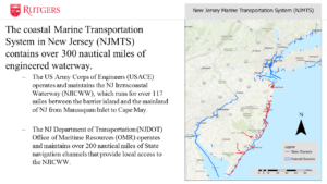
Dr. Miskewitiz described the coastal Marine Transportation System.

In his introductory remarks, Mr. Sarmad noted that nearshore placement of dredged sediment is a natural and nature-based features strategy that offers the dual benefits of providing ecosystem enhancement and reduction of coastal flooding while providing a viable, cost-effective long-term beneficial use option for disposal of dredge materials.  However, Mr. Sarmad noted that improper placement of dredged materials can damage habitat or wash away, providing little or no benefit. Strategic placement requires knowledge of site conditions and sediment transport behavior to provide ecosystem enhancement and resiliency.

Mr. Sarmad then introduced Dr.  Robert Miskewitz, Associate Research Professor within the Rutgers Department of Environmental Sciences and the Center for Advance Infrastructure and Transportation (Rutgers-CAIT), and Dr. Daniel Barone, Associate Research Professor within the Rutgers University Department of Marine and Coastal Sciences (DMCS), the Department of Geography and Rutgers-CAIT who, respectively, presented their research on the development of a Delft3D morphological model to improve estimation of channel shoaling along the Shark River waterway, and the lessons being learned from a nearshore sediment placement project at Goodluck Point in Berkeley Township, NJ.

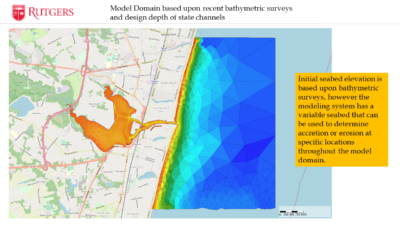
Dr. Miskewitz described how the computer model domain was informed by tidal conditions, bathymetric surveys and design depths.

Dr. Miskewitz’s presentation, Morphological Sedimentation Model Development and Integration within Maritime Transportation System (MTS) Applications, described an approximately two-year research project underway in association with Dr. Barone on the Shark River waterway. The research seeks to establish a model framework for assessing sediment transport in the NJ Maritime Transportation Systems.

He outlined the challenge of maintaining a coastal maritime transportation system in NJ, a system of 300 nautical miles of state and federal channels, that continuously fills with sediment.  Dredging is required to keeps channels usable for marine ports and smaller recreational boating channels, which are all essential to New Jersey’s economy. However, maintaining navigable channels is expensive, meaning the amount that can be dredged is limited based on the existing fiscal resources despite the overall need for dredging based on the amount of sediment being accumulated each year.  Recognizing that sediment deposition rates are not uniform among areas, tools are needed for the informed setting of priorities for the allocation of resources.

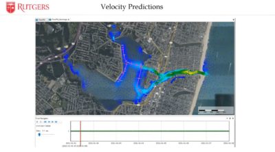
Dr. Miskewitz shared a visual simulation of how flow rates vary by locations and depth in the model

Dr. Miskewitz shared a visual simulation of how flow rates vary by locations and depth in the model.

Their research seeks to inform and supplement the multiple systems offered by NJDOT’s Office of Maritime Resources (OMR) – the Dredged Material Management System (DMMS), Waterway Linear Referencing System (WLS), and Maritime Asset Management System (MAMS) – that are being used to assess the state of the marine transportation system, what is required to get it to a “state of good repair”, and then keep it in a “state of good repair”. Then, as part of the dredging process, the questions turn to what to do with the dredge materials – how best to dispose of them or reuse them to put to a beneficial use.

Dr. Miskewitz explained that historically the estimation of sediment shoaling in the NJMTS has been accomplished via a highly simplified empirical sedimentation model. Dr. Miskewitz explained that channel depths are measured every few years, with data predicting infill rates and shoaling based on simple equilibrium depths between two points. In contrast, Dr. Miskewitz described their efforts to develop a more complex process-based hydrodynamic model, offered by the Delft3D model, which allows for more detailed prediction of sediment transport up to 2 years out.

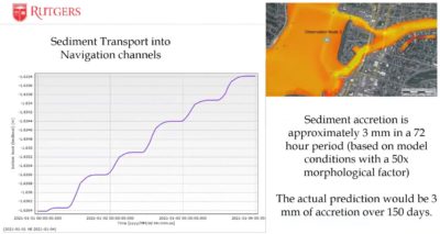
Dr. Miskewitz explained his estimates of the rate of sediment accretion over time.

Dr. Miskewitz explained his estimates of the rate of sediment accretion over time.

To pilot this process-based hydrodynamic model, Shark River’s small network of maintained state channels was selected as ideal for small-scale testing. Sediment can vary by grain size and source, behaving differently based on these factors. This is crucial for modeling, as the muddy sediment in the Shark River does not move discretely like grains of sand. Rather, it breaks in chunks after a critical shear force is met, allowing currents to flow into the holes created, further undermining its cohesion.

The Delft 3D model allows for multiple parameters to be set, including bulk settling velocities for certain sediment types, measured from samples which had been collected.   The model that has been developed includes a fine fraction (silts and clays) and a coarse fraction (sand). Samples were analyzed to determine the fine content versus the coarse content and to inform the model’s characterization of the erodible layer.

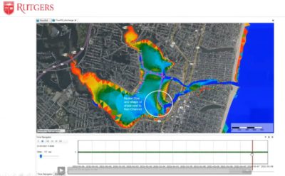
The modeling process itself is very resource-intensive and, thus far, has only been run for a limited 3-day period, but allowed for extrapolation to estimate sediment accretion over time. The predictive model showed that shoals near channels are being destabilized, despite small changes in overall sediment levels. Dr. Miskewitz pointed to a ridge of shoal pushing outward and away from the channel, explaining that this means sediment is being suspended and other channels are shallowing.

Dr. Miskewitz shared examples of the model's visualizations of accretion and changes in shoals over time.

Dr. Miskewitz shared examples of the model’s visualizations of accretion and changes in shoals over time.

As the current project continues, Dr. Miskewitz described the research team’s tasks to calibrate the hydrodynamics against observation, eventually running long-term (2 to 3 years) model simulations, and investigating the impact of extreme episodic events (like Hurricane Sandy) compared to normal accretion rates.

Ultimately, the long-term goal is to develop the capacity to run the model in real-time for the entire NJ Maritime Transportation System and incorporate the model into NJDOT’s OMR’s MAM model to better manage the sediment transport predictions and better manage the resources for dredging.  He noted their current plans to integrate new computer server capacity to perform the requisite sediment transport modelng in a timely fashion and at the scale envisioned for aligning with these goals.

Dr. Barone’s presentation, Goodluck Point Monitoring and Modeling Nearshore Placement of Dredged Materials, described ongoing research of a nearshore placement project in Berkeley Township. Owned by the Forsythe National Wildlife Refuge, the subject lands are a narrow sandy estuarine beach and dune system fronting a tidal marsh. His research involved a pre-dredging assessment of marine conditions (e.g., turbidity, current, wave conditions, etc.) and tracked the extents of sediment plumes from the filling operation. Then he assessed conditions at 3, 6, and 12 months after placement to see how beach morphology was affected, with an 18-month post-placement survey forthcoming.

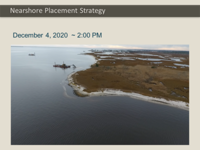
Dr. Barone shared several images and video captured by UAS, including of a barge used in pumping dredged materials.

Dr. Barone gave an overview of the several data collection methods used for monitoring and modeling the results of the beneficial use project before, during and after dredging.  He shared video taken by an unmanned aerial system (UAS) of a barge pumping roughly 6000 cubic yards of suitable dredged material (more than 70 percent sand) in a 1700ft linear bar near the shore.

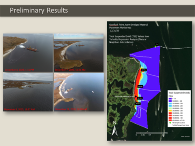
Preliminary results showed that turbidity was relatively high, but not significantly higher during the project. (Ironically, turbidity was far higher prior to the project starting due to a storm event, then falling much lower just before the project commenced.)

Dr. Barone illustrated how UAS aerial surveys illustrated visible plumed before, during and after dredging.

Dr. Barone illustrated how UAS aerial surveys were able to display visible plumes before, during and after dredging.

Dr. Barone shared images of the visible plumes, which were largely confined to the placement area. A major storm event occurred during the first month post-placement, moving most settlement onshore and into the southern area, where there is a small cape. After 12 months, only 42 percent of the placed sediment remained in the placement zone at Goodluck Point, with dominant alongshore sediment transported to the south.

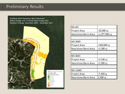
Across the entire mapped project area (including beach, berm and offshore), a total volume loss of 7,100 cubic yards was observed between the Before-Dredge survey and 12 months post-fill. Similar losses across the entire mapped areas were observed between Before-Dredge and After Dredge.  Seaward shoreline movement – that is, accretion, occurred in the southern 715 feet of the project area over the survey period.

In future projects, he suggested consideration of alternative placements, such as feeder beaches. By experimenting with placement and validating against the hydrodynamic morphological model, he hopes that the better modeled flows will inform and improve placement strategies.

Dr. Barone highlighted volume loss and geographical shifts of nearshore berm placement of dredge materials placement over time based on surveys.

Dr. Barone highlighted volume loss and geographical shifts of nearshore berm placement of dredge materials placement over time based on surveys.

Following the presentations, Mr. Sarmad moderated questions posed by participants via the chat feature.

Q. Did freezing the cores of sediment samples impact the shear measurements?

Dr. Miskewitz: That they may have. We froze them because we had to wait months before students were available to process and we did not want anything to grow, as these samples are pretty much alive.

Q. Regarding the bridge at Highland Avenue: Does the model measure the changes in elevation and speed?

Dr. Barone:  This is a depth average model, not a 3D model.

Q. How well can you simulate Hurricane Sandy?

Dr. Miskewitz: That type of simulation will be done based on adjusting boundary conditions. Some affect from wind, but probably not as much as water level going up. The release of everything being inundated and then washed out, carrying stuff with it, is the dominant factor in erosion.

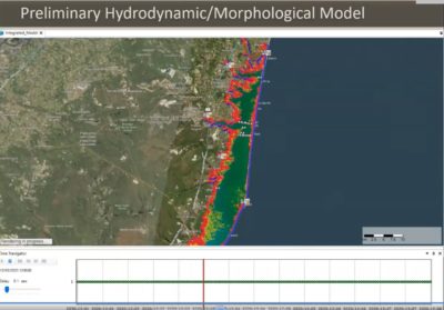
Dr. Barone shared several visualizations and explained how the hydrodynamic /morphological model can be used to optimize locations, configurations, and timing of dredge materials placement

Dr. Barone shared several visualizations and explained how the hydrodynamic /morphological model can be used to optimize locations, configurations, and timing of dredge materials placement.

Q. Does the popularity of the channel affect the frequency or priority of dredging? (e.g., compared to residential areas)

Dr. Miskewitz: That is a question best directed to NJDOT’s OMR, not for us, but it is based on many things that would drive decisionmaking at which I’m not qualified to comment.

Q. Was the project permitted as a pilot project, or did it not have that designation?

Dr. Barone: It did not have that designation. OMR partnered with the Forsythe Wildlife Center, who controlled the project and NJDOT partnered with them to provide technical resources.

Q. How do you test the accuracy of your preliminary model?

Dr. Barone: We compared our survey data with model output such as time-varying bed levels, but also ADCP (Acoustic Doppler Current Profiler) data, so we can validate velocity and water level and tide gauge.

Q. Were there any other locations identified as potential areas for similar observation?

Dr. Barone: The plan is to do this for the entire state’s navigation channels. Regarding Goodluck Point specifically, marshes are not getting bigger and beaches continually need sediment since there is an absence of sediment supply, so there are lots of places that will need this kind of work.

Dr. Miskewitz: We have a couple of projects in the area and further south that will get similar treatment.

The presentations described several technical analytical considerations in handling data and defining modeling parameters and contained several visual simulations that can best be appreciated by viewing the webinar recording, which is available here, (or see right).

NJDOT Tech Talk! Webinar – What Happens Now? Virtual Public Engagement During and Beyond Covid-19

The New Jersey Department of Transportation Bureau of Research convened a Lunchtime Tech Talk! Webinar on What Happens Now? Virtual Public Involvement During and Beyond COVID-19 on October 6, 2021. Amanda Gendek, Manager of the NJDOT Bureau of Research, welcomed everyone to the event which included presentations by five representatives of public sector transportation agencies who discussed the immediate transition and ongoing adaptation to virtual platforms to engage with the public for transportation plans, projects, and other activities, and the benefits and challenges associated with this shift. Of particular emphasis was outreach to underserved and vulnerable populations.

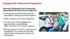
Facilitators for the Tech Talk, Andrea Lubin and Trish Sanchez, from the Rutgers University-Voorhees Transportation Center, Public Outreach and Engagement Team (POET), opened the session with reference to their work on NCHRP Synthesis 538: Practices for Online Public Involvement, and the next phase of work, NCHRP 08-142 Virtual Public Involvement (VPI) – A Manual for Effective, Equitable, and Efficient Practices for Transportation Agencies. During the pandemic, Rutgers POET has conducted public engagement which transitioned to virtual for the South Jersey Transportation Planning Organization, Somerset County, and Middlesex County’s Destination 2040 projects. Ms. Sanchez noted the need to experiment with different engagement practices to find what works for each community, and the benefits of building partnerships with local organizations to reach a broad audience. She also noted challenges with VPI such as the digital divide, internet access, and staffing. Ms. Lubin discussed a 2020 study conducted for the Kessler Foundation and interviews with social service agencies and community organizations that offered lessons learned when conducting virtual outreach with vulnerable populations. Despite challenges, Ms. Lubin emphasized that VPI has expanded engagement opportunities in many instances to those who had previously been unable to participate in-person due to obstacles including transportation and childcare.

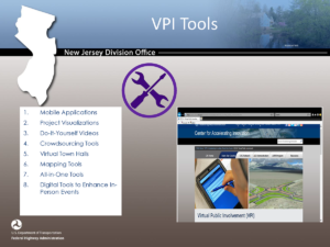
Rickie Clark, Transportation Specialist with FHWA, noted that Virtual Public Involvement (VPI) is one of the innovative initiatives supported in the fifth and sixth rounds of the agency’s Every Day Counts Initiative. He reviewed the legislation and regulations that requires early and continuous public involvement in the transportation planning and project development process. To meet those requirements during the COVID-19 pandemic, FHWA issued VPI Temporary Guidance that will remain in effect until the pandemic has ended. Mr. Clark encouraged the use of a wide array of VPI tools that can be customized to the needs of particular projects and audiences. VPI extends outreach to the public and enables the public to engage with transportation officials efficiently and effectively. For those who have limited access to the internet, he emphasized that transportation agencies must provide alternatives to ensure full, fair, and meaningful participation for all. Mr. Clark noted that New Jersey is using many VPI innovations.

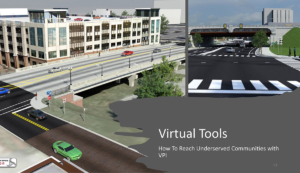
Jamille Robbins, Public Involvement, Community Studies & Visualization Group, Leader, North Carolina DOT, spoke on how his agency has reached underserved communities with VPI. He discussed the importance of pursuing thoughtful marketing to support the success of VPI and other outreach efforts designed to educate and inform the public and other stakeholders in the transportation project development process. He explained that broadening outreach and increasing engagement contributes to transparency and builds trust. He noted that social media is an effective tool for reaching rural, lower-income, Black, Hispanic, and less-educated populations, and that mobile phone friendly communication is essential.  However, agencies should not be solely relying upon VPI. Traditional media, webpages, partner agency and organization networks, newsletters, postcards, door hangers and local access television and radio remain effective tools for reaching traditionally underrepresented groups. Similarly, integrating the use of phones to collect public comments can augment traditional methods for collecting input, such as paper surveys. Mr. Robbins shared experiences with utilizing a variety of VPI tools and platforms including public engagement software such as publicinput.com and the social networking service Nextdoor. He also described pre-recorded project information videos as a highly effective tool for controlling messaging and highlighted the agency’s use of online engagement platforms for live meetings, with the recordings placed on the web, so that constituents can access them and provide feedback at any time. Mr. Robbins also promoted the use of project visualizations, including 3D renderings and interactive animation that can be easily dispersed across online communication channels and improve understanding of proposed projects. While sharing many tools creatively being used by NCDOT, Mr. Robbins balanced his remarks with several takeaways and lessons learned observations about the limitations of VPI for reaching underrepresented communities.

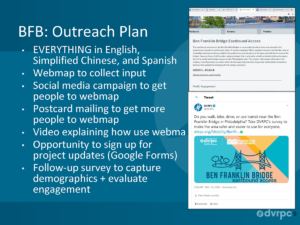
Alison Hastings, Associate Director, Communications, Delaware Valley Regional Plan Commission (DVRPC) spoke about the agency’s use of VPI in the Long Range Plan 2050 Visioning process, and for the Ben Franklin Bridge Eastbound Access project, and the regional MPO’s anticipated integration of VPI for public involvement in the post-pandemic era. When pivoting from in-person public engagement to virtual events, Ms. Hastings listed several themes that required consideration:  accessibility and accommodations, recreating the in-person experience, setting ground rules and ensuring security. She also described her team’s considerations in determining the specific staffing roles needed for their virtual events, such as lead facilitator, technical assistance leader, and comment response facilitator, among other roles. She noted identifying these positions has helped to ensure smoother virtual events.

DVRPC has used many VPI platforms and tools, both old and new, such as videos, targeted social media campaigns, live transcription and captioning in meetings, web maps, and postcard mailings and noted that public participation has increased with their VPI efforts. Ms. Hastings discussed the advantages of meeting platforms that run well on browsers and smart phones and enable participation in underserved communities that lack internet access. In the future, DVRPC’s equity checklist will include using American Community Survey data to understand the demographics of the project area, communicating why the meeting is important, using Google forms to build contact lists, preparing the team for the challenges of online meetings, experimenting with different outreach, and evaluating the VPI process.  She anticipates that hybrid meetings – in person and virtual – will continue and may require additional staff to run efficiently to achieve desired outcomes.

Vanessa Holman, Deputy Chief of Staff and Megan Fackler, Director of Government and Community Relations at NJDOT explained that their Public Information Centers (PICs) and other outreach must be compliant with Title VI requirements. Due to the pandemic, they needed to find ways to bridge the digital divide which is economic, generational, and geographic. NJDOT has combined established methods of engagement with virtual methods, and in particular, collaborated with stakeholders through social media, websites, and digital news sources. They noted that virtual meetings have helped to remove some barriers to participation, such as the need for transportation and childcare. Ms. Holman shared that they have lost some of the interaction typical of an in-person meeting, and noted the different staff demands of online meetings such as prepared scripts. The Department has also expanded communication in other ways, including through 1-2 page project update memos, written in plain language, for public officials. They now tend to over-communicate and continue to use a range of tools. These efforts are resulting in more public participation and comment in general.

Public involvement tools are available to engage underserved and vulnerable populations and expand outreach so every community member can participate in transportation decision making. Click for Andrea Lubin and Trish Sanchez's presentation

Mr. Clark noted that there is no one-size-fits-all public involvement process and promoted the use of an array of public involvement tools to communicate with the public and receive input. Click for Rickie Clark's presentation

North Carolina JDOT uses 3D visualizations and interactive animation, among other tools, to help public involvement participants understand proposed projects and impacts.

North Carolina DOT uses 3D visualizations and interactive animation, among other tools, to help public involvement participants understand proposed projects and impacts. Click for Jamille Robbins' presentation

DVRPC used both old and new methods of communication for the Ben Franklin Bridge Outreach Plan. Click for Alison Hastings' presentation

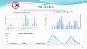
NJDOT was successful with their two-week, on-line PIC for the Rt. 80 and Rt. 15 Interchange project. They received large volumes of survey responses and discovered key times for public participation that will inform future efforts. Click for Vanessa Holman and Megan Fackler's presentation

At the end of the event, the speakers responded to questions posed by attendees through the platform’s chat feature.

Q. How expensive is NextDoor?

Jamille Robbins: I don’t believe there’s a huge cost associated but I would have to check with our social media coordinator.

Q. What program did North Carolina use to do 3D presentations?

Jamille Robbins: We use 3D Studio Max for a lot of the presentations.

Q. How do you provide for two-way communications and conversations in an online environment that would occur at in-person events?

Alison Hastings: The platforms, such as Zoom, help. The chat box becomes a primary source of input since you can save it. Conversations can happen in breakout rooms with small groups and a facilitator sharing a screen while using Google docs to record notes. Platforms push updates that provide these tools to emulate the in-person experience.

Trish Sanchez: Break-out groups allow people to feel more comfortable speaking openly.

Andrea Lubin: Especially if they are intimidated by large groups.

Q. What are typical costs for publicinput.com?

Jamille Robbins:  North Carolina uses it on all projects and it is cost-effective, but I do not know specific costs.

Q. For NJDOT: Have you received feedback, either positive or negative, on the VPI process or the platforms used and has that encouraged you to change anything in your VPI strategies?

Megan Fackler: Not thus far. We have received questions on the platform, and requests for technical assistance. It is important to provide a phone number for people to reach out prior to a meeting if they are having difficulties accessing the meeting.

Q. For Rickie Clark: If a municipality requested an in-person event, would FHWA provide guidelines for conducting such a meeting?

Rickie Clark: The possibility for in-person meetings would depend on state and municipal guidance for in-person engagement, as well as the guidance of local health officials. During the pandemic, the VPI Temporary Guidance is in effect.

Q. If you could offer one piece of advice for VPI for underserved or vulnerable populations, what would it be?

Andrea Lubin: What I heard from Jamille was the power of radio advertising to target outreach, based on the number of people who are regular radio listeners.

Rickie Clark: From the federal perspective, agencies must have a public involvement plan in place to begin with. Agencies should evaluate the effectiveness of VPI tools. DOTs have become more nimble in modifying their approach. Imagine a time after COVID-19 when a hybrid model can be used and start planning now. It will be a win-win.

Jamille Robbins: Look at the demographics of the area and population characteristics. If there are EJ or LEP communities, reach out to the local planning office or someone familiar with the area. This is the most effective way to get into those communities.

Q. How do you handle data protection in the VPI process?

Alison Hastings: Don’t ask the question if you can’t protect the information you gather. Also, sunset dates determine how long a survey remains open. Set a date for expunging contact information after gathering that information. Use the same process for focus groups.

Jamille Robbins: We are simplifying the demographic information we are requesting. Asking for a name, email, and address may pass a threshold. Keep in mind that information gathered at a public meeting is a matter of public record.

A recording of the webinar is available here.

Reads: Lunchtime Tech Talk! The NJDOT's Pavement Support Program (PSP), Goals, Deliverables, and the Future, Thursday July 22, 2021, 12pm to 1:15pm

Lunchtime Tech Talk! WEBINAR: NJDOT’s Pavement Support Program—Goals, Deliverables and the Future

Dr. Thomas Bennert, of the Center for Advanced Infrastructure (CAIT) at Rutgers University, presented on Thursday, July 22, on his work leading the Pavement Support Program (PSP) for NJDOT’s Pavement & Drainage Management and Technology Unit. Dr. Bennert discussed in detail PSP’s current research and applications, explaining how a variety of innovative materials and technologies are being developed and applied to improve pavement performance across the state.

Dr. Bennert's talk provided an overview of the pavement program’s recent deliverables, as well as highlighted the future goals of the program. The PSP has several objectives and touches upon many disciplines from materials evaluation to supporting pavement management activities to addressing pavement design needs to assisting in training and workforce development. The PSP serves as an extension of the NJDOT workforce activities under the direction of the Pavement & Drainage Management and Technology Unit at NJDOT, which also helps to support the needs of the NJDOT Materials Bureau to inform materials characterization for more accurate pavement design and evaluation.

Since 2006, the PSP has assisted NJDOT through research and technical assistance related to pavement performance. Because of this continual, fifteen-year operation, data is available today that demonstrates the positive effects of the program’s work, such as how various asphalt composites have performed over time in comparison to traditional asphalt mixes.

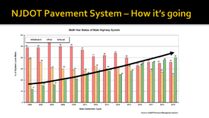
Slide reading NJDOT Pavement System, how it's going. A bar graph of deficient, fair, and good pavement statuses, with deficient tending down since 2006, and good trending upwards.

Data indicates a steady upward trend in the condition of New Jersey’s highway pavement, due to the sustained implementation of PSP’s research and deployment of various pavement preservation treatments

Dr. Bennert organized his talk by the seven major support tasks of the PSP, highlighting the purpose, examples and upcoming activities for each task. For the program’s first task, Innovative Materials, the program has focused on the development and improvement of specifications for roadway pavements, such as asphalt and concrete, to extend the life of the pavement. High Performance Thin Overlay (HPTO) was one of several examples whose purpose, design attributes and benefits were discussed. This pavement treatment improves rut and crack resistance, and extends the life expectancy of some pavements by over five years.

Dr. Bennert also touched on the rationale and challenges of applying another materials innovation, High Friction Surface Treatment (HFST), which was promoted as an FHWA Every Day Counts (EDC) initiative in 2015. While horizontal curves make up only 5 percent of U.S. roadways, more than 25 percent of total roadway fatalities occur on these sections. One way to increase friction in these areas is to apply an HFST, though the pavement must be in good condition. In New Jersey, rapid temperature swings can affect the epoxy on degraded asphalt, creating shallow potholes. To counter this failure, Dr. Bennert and his team have developed both a pre-screening protocol to determine whether a curve is suited for HFST, and a different adhesive more suited to asphalt.

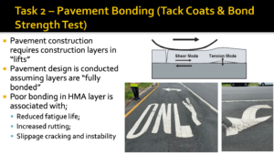
Slide reads Task 2 - Pavement Bonding (Tack Coats & Bond Strength Test), with immages of defromed pavement. A graphic shows how tension between two layers of pavement that are not properly bonded creates space for friction. Bullet points read: Pavement construction requires construction layers in "lifts." Pavement design is conducted assuming layers are "fully bonded," Poor bonding in HMA layer is associated with, reduced fatigue life, increased drutting, and slippage, cracking, and instability.

The program team developed ways to improve pavement bonding in roadway construction

PSP is also tasked with researching innovative practices and technologies to improve the efficacy of the paving process. One example that Dr. Bennert shared involved researching ways to improve the pavement bonding. Two common problems are slippage, where the top layer does not adhere properly and begins to slide away, and more widespread tension issues, in which failure to bond causes uneven loads, warping the pavement. To avoid premature failure, the program has developed performance-based specifications for tack coats (the term for the adhesive layer between tiers of asphalt), a testing mechanism to better understand the properties of tack coats, and new criteria for construction practices to ensure that pavement is put together properly.

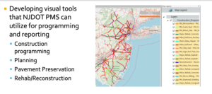
The PSP includes a pavement management system support task to assist NJDOT in the collection of data, the management and quality control of data, and the application of data to inform decision-making priorities. For example, the NJDOT Pavement Management group conducts yearly pavement condition assessments to help forecast needs of pavement activities and funding allocations to optimize budgetary resources for pavement preservation and larger rehabilitation and reconstruction projects. This process uses Pavement Management Systems (PMS) condition and program mapping, and future work is expected to continue to incorporate GIS mapping models to create an even more comprehensive picture.

Until recently, the status of the state’s many miles of pavement has been historically performed using an employee’s vision and judgment. Instead, PSP is looking to deploy cameras and computer-based processing power along roadways to automate data collection for developing surface distress index ratings, and even to calibrate and predict the infrastructure’s future performance to inform Pavement Design.

Slide is a map of New Jersey with colored lines across its roads, reflecting pavement conditions. Text to the left reads Developing Visual Tools that NJDOT PMS can utilize for programming and reporting, Construction programming, Planning, Pavement Preservation, and Rehab and Reconstruction

New methods in data collection and mapping allow for a more comprehensive picture of pavement conditions across the state

Finally, PSP engages in policy analysis, develops white papers on current and emerging practices, and provides technology transfer and trainings for NJDOT. Such work includes Cost Benefit Analyses (CBAs) to determine the cost effectiveness of new materials, tackling the question of whether the additional costs to manufacture can be justified by the additional years added to the roadway’s life cycle. Dr. Bennert shared slides showing how CBAs of HPTO and several other hybrid asphalt mixes had higher Benefit/Cost Ratios than traditional Hot Mix Asphalt (HMA). The program engages in trainings and presentations with NJDOT regularly, presenting on research and technological innovations, and facilitating technology transfer and continuity for newer staff.

Dr. Bennert concluded his presentation by commending NJDOT as a national leader in performance testing for asphalt and handling of composite pavements. The Pavement Support Program will continue to address the immediate needs of the Pavement & Drainage Management and Technology Unit at NJDOT, sustaining their research, development, and implementation of cutting-edge pavement technologies. “What we’re doing here is making a big impact in the state.” Dr. Bennert said.

Afterward, Dr. Bennert answered audience questions in a brief Q&A.

Q. How does New Jersey compare to other states in our use of high performance thin overlay (HPTO)?
Dr. Bennert: We’re working with FHWA on the EDC-6 rollout of HPTO. We use it significantly more than most states, besides Texas. New Jersey is a leader on performance testing in general.

Q. How widespread is the use of the High Friction Surface Treatment (HFST) in New Jersey?
Dr. Bennert: While I don’t have the crash reduction data, I do know that it’s been used successfully by the state and some municipalities as well. As shown earlier, there have been some failures with the technology’s application, which we are now working to identify the reasons for failure and reduce through our research.

Q. As reported in the HFST guidelines, why do you think an early drop in skid resistance was observed in the treatment’s application, despite the very hard aggregate that was used?
Dr. Bennert: Simply, it is due to the material loosening in the epoxy. The embedment depth of that aggregate is very important. If it’s too deep, the aggregate is almost drowning in the epoxy, and if it too shallow, it can pull out very easily as vehicles travel over it. The recommendation is to monitor the HFST over the first few years. Because HFST has a limited shelf-life, monitoring friction is very important.

Q. How many sub-consultants do you have on this project, and which private consultants are contracted as sub-consultants?
Dr. Bennert: Currently, the only group that we have working with us on the contract this year is the company that manufactures the software for the pavement management system. This can change based on the needs of Pavement & Drainage Management and Technology Unit at NJDOT.

Q. Could you speak on pavement mix testing for future climate concerns?
Dr. Bennert: We have tests and thresholds for how the material should be performing, and additional heat will often stiffen the material a bit more, which can further age the pavement. We could get some increased, accelerated stiffening. PSP has been working with NJDOT on test methods to identify appropriate asphalt materials and test methods to help identify materials that are prone to aging, which could be especially useful to address climate concerns.

Q. What is the future of Cold Mix Asphalt and its potential use on heavily truck trafficked New Jersey highways?
Dr. Bennert: In New Jersey, we don’t have low volume roads where we could put material out without an overlay. Without some kind of confinement, the material could easily break apart. I’m looking forward to the rollout of central plant technology, which will allow us to take material from a project and put that back, an almost 100 percent recycling of the material for a project’s base application. This would be a base application to help reduce the recycled asphalt pavement stockpiles in the state.

Q. Did you test Ultra-Thin Friction Course and how does it compare to High Performance Thin Overlay?
Dr. Bennert: Ultra-Thin Friction Course can be thought of as a treatment option between an Open-Graded Friction Course and a Chip Seal. It’s used more for pavement preservation, rather than structure, but it does a good job at sealing off the pavement. The High Performance Thin Overlay is thicker, and helps to provide structural integrity of the pavement, both sealing it and adding rutting and cracking resistance. There’s a difference in the thickness of the materials, and the targeted applications.


A recording of the webinar is available here, (or to the right).

Dr. Bennert’s presentation can be found here.

Resources

Federal Highway Administration. Targeted Overlay Pavement Solutions. https://www.fhwa.dot.gov/innovation/everydaycounts/edc_6/targeted_overlay_pavement.cfm

Bennert T. and D. Pezeshki. (2015). Performance Testing for HMA Quality Assurance. Report, Rutgers, Center for Advanced Infrastructure and Technology. FHWA-NJ-2015-010. https://cait.rutgers.edu/wp-content/uploads/2018/05/fhwa-nj-2015-010.pdf

NJDOT Technology Transfer. Pavement Preservation at NJDOT. Video. https://www.youtube.com/watch?v=n1wlnB8AQ-g&t=128s

Image reading WEBINAR Lunch Time Tech Automating the Traffic Signal Performance Measures for NJDOT Adaptive Traffic Signal Control Systems

Lunchtime Tech Talk! WEBINAR: Automating Traffic Signal Performance Measures for NJDOT Adaptive Traffic Signal Control Systems

Slide Cover Reading Lunchtime Tech Talk! Automating the Traffic Signal Performance Measures for NJDOT Adaptive Traffic Signal Control Systems - Real-Time Signal Performance Measurement (RT-SPM)

Click For Tech Talk Presentation

The New Jersey Department of Transportation Bureau of Research convened a Lunchtime Tech Talk! Webinar on Automating the Traffic Signal Performance Measures for NJDOT Adaptive Traffic Signal Control Systems on June 29, 2021. The presentation was led by Dr. Peter Jin, of Rutgers-CAIT, Dr. Thomas Brennan, from the College of New Jersey, and Kelly McVeigh from NJDOT’s Mobility Engineering Unit. The three touched upon Phase I research on Real-Time Traffic Signal Performance Measurement and continuing research underway in Phase II  to adapt NJDOT’s existing signaling technology to take advantage of innovative methods in optimizing traffic controls.

Kelly McVeigh, of NJDOT, began the event by introducing the Automated Traffic Signal Performance Measures (ATSPM) and Adaptive Traffic Signal Control Systems (ATSC) concepts. According to McVeigh, Automated Traffic Signal Performance Measures are a suite of measures that help transit agencies to make use of data in optimizing signal timings. ATSPM consists of a dataset of time-stamped events—visually represented through charts—that demonstrate the signal’s performance. For example, how much time the signal is set to green when vehicles are present. The technology, McVeigh said, was “a powerful tool in the toolbox for traffic engineers to monitor performance and even make changes, if agency procedures allow.” ATSPM was first introduced by FHWA as part of the fourth round of the Every Day Counts Initiative (EDC-4).

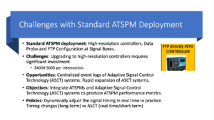
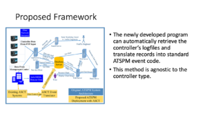
Slide Reads Challenges with Standard ATSPM Deployment, Standard ATSPm Deployment: High-resolution controllers, data probe and FTP configuration at Signal Boxes. Challenges: Upgrading to high-resolution controllers requires significant investment, $4,000 to $5,000 dollars per intersection. Opportunities: Centralized event logs of Adaptive Signal Control Technology systems. Rapid expansion of ASCT systems. Objectives: Integrate ATSPMs and Adaptive Signal Control Technology )ASCT) systems to produce ATSPM performance metrics. Policies: Dynamically adjust the signal timing in real time in practice. Timing changes (long-term) versus ASCT (real-time/short-term).

In order to avoid costly infrastructure costs of replacing ASCT systems for ATSPM equipment, the researchers devised a method to make use of existing, deployed intersection systems.

McVeigh explained that, while there is already a well-documented system in place to support ASTPM implementation, NJDOT is focusing on adapting existing systems that are already equipped to capture data. Adaptive Traffic Control Systems (ATSC) are installed in nearly 20 percent of NJDOT’s roughly 2,500 signals statewide, and collect data on both traffic controllers and detectors, such as signal performance and vehicle queuing. However, as Dr. Jin then detailed, ATSC data is presently incompatible with ATSPM. In addition, some signals are connected to the centralized network, while others remain isolated. The solution was to develop a means of converting the data, rather than installing new infrastructure.

A team of students from Rutgers, The College of New Jersey, and Rowan University worked with Dr. Jin to bridge data from ATSC to ASTPM. The proposed solution is a program that automatically retrieves traffic controller event logs and then translates them into ASTPM event code, a method that is agnostic to controller type. This allows for a wide variety of data to be collected, and then viewed and optimized using standard ASTPM methods.

Slide image of proposed farmework with a new add on of existign ASCT Sytems going ot get event logs, to ASCT event translator to push ATSPM events, to Database server. The two bullet points read The Newly developed program can automatically retrieve the controller's logfiles and translate records ito standard ATSPM event code. This method is agnostic to the controller type.

The proposed framework would add direct conversion of ASCT events to ATSPM.

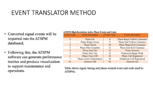
Data translation works by taking ATSC logs, such as “Phase Begin Green” stamped with a timecode, and converting that to a numeric code, in this case, “1.” A computer program reads through the SCATS log and assigns certain datapoints to traffic events, such as a gap, which would be coded as “4.” At the conclusion of Phase 1, the team has been able to convert all major events to ASTPM metrics. Going forward, they are working on using geolocated video data to reconstruct stopping data, allowing for more refined information that enables real-time traffic signal adjustments.

Many locations on NJDOT’s network are not properly equipped to convey upstream information on vehicles, particularly during the red phase. The ingenious solution is to locate a “Stop-Bar” within the signal detector that registers when vehicles have begun queuing. This data is then correlated with spatial Google Maps data that precisely locates the vehicles’ position. Information from the Autoscope video-based tracking technology is then used to calculate the vehicle’s trajectory, using the Shockwave Theory of traffic flow. The benefit of such a method is better data on how vehicles approach a red signal, which can then be optimized through ASTPM.

Reads event Translator method, converted signal events will be imported into this ATSPM database. Following this, the ATSPM software can generate performance metrics and produce visualization to suppport maintenance and operations. Table shows signal timing and phase-related event and code used by ATSPMs.

ASTC events are translated using a computer program that can recognize various events and code them as such.

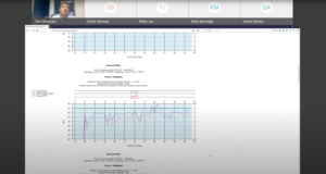
Dr. Brennan then demonstrated the technology in action, sharing his screen to show the ATSPM Server and its variety of tools. He selected a sample intersection, US-1 and Harrison Street near the Millstone River, and brought up a chart showing the Purdue Phase Diagram (PCD). The PCD is a means of graphically representing the number of vehicles passing through an intersection with respect to phase time. In an ideal situation, vehicles should arrive on green, instead of red, when they will have to wait. Another chart represented the traffic split by time of day and duration of the phase. When the technology is fully implemented, such data should be uploaded every 15 minutes, allowing for near real-time monitoring.

From the ATSPM data, Dr. Brennan showed that one signal had an 82 percent Arrive on Green (AoG) score. Metrics such as this could be used for the development of data-driven policy. The dashboard charts also showed vehicle density for when the signal was about to turn red—the timing of which could be adjusted to lighten the number of vehicles queuing.

Screenshot image of a white website with a blue graph, showing dark blue and red squiggles, which are traffic flow data at the intersection throughout the dat. Above, Dr. Tom Brennan can be seen explaining.

A live demo of the converted ATSPM dashboard demonstrated how useful the technology will be for making intersections more efficient.

It was clear that the conversion of ATSC data to ATSPM dramatically expanded the potential of every intersection in which it is equipped. The dashboard could be used to model changes in traffic flow, such as if a road diet were implemented, or if traffic from a major highway was diverted through the intersection. Safety benefits include data on red light violations that can be tabulated and used as justification for future improvements. One day data from connected vehicles could be integrated, too.

At the end of the presentation, Dr. Jin summarized their work: the team had innovated in converting raw data to ASTPM protocols that could then be used to boost signal performance and traffic flow optimization. This translation method avoids the intensive infrastructure cost of upgrading signals to ASTPM standards, saving money. An in-development model using Stop-Bar data will soon allow for real-time signal adjustment, letting traffic engineers tweak signal timings for optimal flow. At NJDOT, they are in the final stage of deploying this technology permanently on an agency server for future widespread use.

At the end of the event, several attendees asked questions through the platform’s chat feature.

Q. Inrix data does not provide individual probe data, how is it accounted for in the results?
Dr. Brennan: We’re not able to get individual vehicles, but it aggregates vehicle speed within one-minute increments. This then feeds that into ASTPM as if it were a single detector. Everything is within a confidence interval of 85 percent. The beauty of this software is that as long as you convert your information into the right format, you can put it in there.

Q. How do you control and change the cycle length tool?
Mr. McVeigh: Part of the adaptive system algorithm is to update cycle lengths in real time, based on the data being received. We can also provide guidance to the system on thresholds, on minimum and maximum lengths for cycles throughout the day. This is all for adaptive systems—coordinated systems use modeling to update their lengths. The tool used primarily at NJDOT is Synchro.

Q. How did the COVID-19 pandemic affect the data collection on Route 1?
Dr. Brennan: Because the researchers were working to calibrate a tool, the volume of traffic on the roadway did not affect their work.

Q. What are the biggest obstacles that you are facing in advancing this innovation around the state?
Mr. McVeigh: The first obstacle is ensuring that various datasets can be interfaced properly, because the ATSC system is providing data that is not necessarily compatible with ASTPM functions.
Dr. Brennan: There are also issues with code syntax, such as when SCATS is updated and logs data differently. Thanks to the graphical nature of the project, it is easy to see when this is happening.

Q. Did you face any issues in reconciling the Google Maps data with the CCTV data?
Dr. Jin: I think it was more with the video conversion. Google Maps provided good distance information that was then converted to become compatible with the video data. The critical step was coordinating these pixel coordinates to actual coordinates.

Q. What percentage of the adaptive signals are implemented on state highways?
Mr. McVeigh: Right now we have 118 adaptive signals in operation. Out of almost 2,600 signals in the state, a little under 20 percent of signals in the state are equipped with this technology.

Q. With multiple data sets fed into the system, how does it filter to avoid repetitions or duplicates?
Dr. Jin: We do have to filter the data that is fed in, and also have developed the logic that shows which line confirms the event occurred, and which line shows the starting point of the event. This is part of the translator work. In terms of different data sources, we were able to coordinate pretty well.

Q. Do you have any suggestions based on your research to help county and local governments advance the implementation of ASTPMs?
Mr. McVeigh: It’s a very powerful tool, make sure you have the practice to enable it to be used properly. From a technical standpoint it’s relatively straightforward, but the big thing is knowing how you want to use it—could be really effectively used as an empirical optimization tool. It all depends on the agency’s ability to do that.
Dr Jin: It is important to start knowing what is currently available, whether there is new construction or existing controllers, to see whether can deploy original ASTPM or these adaptive measures.
Dr. Brennan: It’s important to have strong IT support for these conversion activities. It’s not impossible, but necessary to have the support in place.

A recording of the webinar is available here, (or see right).

Resources

Federal Highway Administration. Automated Traffic Signal Performance Measures. https://ops.fhwa.dot.gov/arterial_mgmt/performance_measures.html

NJDOT Tech Transfer. (2018, December). What is an Automated Traffic Signal Performance Measure (ATSPM)? https://www.njdottechtransfer.net/automated-traffic-signal-performance-measures/

NJDOT Tech Transfer. (2020, June 12). Development of Real-Time Traffic Signal Performance Measurement System. https://www.njdottechtransfer.net/2020/06/12/development-of-rttspms/

NJDOT Tech Talk! Webinar – Research Showcase: Lunchtime Edition

On April 22, 2021, the NJDOT Bureau of Research hosted a Lunchtime Tech Talk! webinar, “Research Showcase: Lunchtime Edition!”. The event featured three important research studies that NJDOT was not able to include in the NJDOT Research Showcase virtual event held last October. The Showcase serves as an opportunity for the New Jersey transportation community to learn about the broad scope of academic research initiatives underway in New Jersey.

The three projects examined various issues in transportation from surface transportation vulnerability to climate change, to the impacts of lighting on work zone safety, to policies that regulate overweight trucks in New Jersey. After each presentation, webinar participants had an opportunity to pose questions of the presenter.

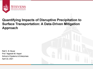
Quantifying Impacts of Disruptive Precipitation to Surface Transportation: A Data-Driven Mitigation Approach. Raif Bucar is a third-year Engineering Management Ph.D. student at Stevens Institute of Technology, currently conducting research on surface transportation vulnerability to flood events. The study adopts a multidisciplinary approach to look at the effects of not only 100 and 500 year floods, but also more frequent events that cause local flooding to assess the impact on mobility and accessibility in Hoboken, NJ. The resulting study explores flooding impacts on the transportation system in terms of mobility and accessibility metrics and can inform the flood mitigation measures and measures to improve resilience.

The study used a traffic simulation model to look at storm magnitude and high and low tide in relation to Vehicle Miles Traveled, Vehicle Hours Traveled, and Trips Completed. Mr. Bucar described analysis of data to predict flood risk and determine areas of higher probability of flooding by year-storm and tide to determine why some areas flood more often than others. The study explored urban characteristics including land cover and topography, elevation, slope, impervious coverage, and drainage system features, and looked at the correlation of these features with flooding.

Mr. Bucar described the application of this information to determine routing information for drivers by applying machine learning to develop a “most valuable path” that adjusts travel time based on each link in the route and diverts drivers in response to changing conditions during flood events. The study findings can also be applied to guide flood resilience transportation planning. Future work will look at other models to validate this study’s assumptions, and will investigate driver behavior during flood events and how drivers respond to new information.

Following the presentation, Mr. Bucar responded to questions asked through the chat feature:

Q. There is not as much research on rainfall-induced flooding. Why not?
A. There may be resistance to using interdisciplinary approaches to exploring this problem. This is an area that needs more research as the disruptive effects of flooding on transportation mobility is increasingly apparent.

Q. How translatable is this approach to other cities or locations?
A. Thus far, we have not applied the framework to other areas, but should be able to apply it to other controlled study areas. A study of larger areas, such as a state, will not show local differences. There is a limit to how much we can scale this model.

Q. How do you plan on factoring in driver behavior and driver knowledge of flood events in future studies?
A. We anticipate using surveys and controlled experiments.

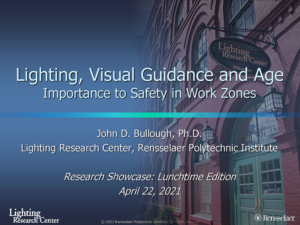
Lighting, Visual Guidance and Age: Importance to Safety in Roadway Work Zones. Dr. John Bullough is the Director of Transportation and Safety Lighting Programs and a Course Instructor in the graduate program in lighting at the Lighting Research Center at Rensselaer Polytechnic Institute.

Work zones are complex visual environments, and particularly so at night when illumination is needed for workers to complete tasks and for drivers to see the work area and understand how to navigate around it. Roadway delineators, and steady and flashing lights used in work zones can cause glare and visual chaos that affect drivers’ ability to see well. These challenges are exacerbated for older drivers due to physical changes in the eye over time.

Dr. Bullough described the Relative Visual Performance (RVP) model used to look at the speed and accuracy of visual processing in relationship to light level, the contrast between an object and the background, the size of an object, and the age of the observer. The research compared the effects of: steady lighting; flashing lights at night and during the day; sign retroreflectivity, color, and lettering; and road delineators on younger and older drivers.

Dr. Bullough noted that, with an aging driving population, the needs of older drivers should be considered to improve road safety around work zones. Study conclusions emphasize that older drivers need higher light levels than younger adults, but warns that higher light levels can create more glare. There is a need for flashing warning light intensity specifications that reflect the needs of drivers of all ages. It was noted that higher reflectivity in sign sheeting can extend legibility distances and so assist older drivers. Dr. Bullough noted that monitoring of light levels is needed throughout their use to keep levels of glare low.

Several questions were posed to Dr. Bullough after his presentation:

Q. Was the information broken down for age groups over 60 years?
A. Optical changes continue to ages 70 and 80. However, there are other potential visual problems among individuals in these age groups – for example, cataracts, macular degeneration, and glaucoma which make generalizations more difficult.

Q. Does the color of light affect glare and visibility?
A. It depends on what we mean by “glare”. Red and blue lights – which we might find on police and flashing lights of highway maintenance trucks – have the same contrast-reducing characteristics regardless of color. However, people tend to be more sensitive to bluer colors; they find them much brighter, more glaring, more annoying and distracting even if they do not affect visibility any more than red or yellow lights of the same intensity. So, depending on what we mean by glare – if it’s that sensation of pain or annoyance – color matters a lot; if it is just visibility than it really comes down to candle-power, or candelas.

Q. What were the overall differences between urban and rural environments?
A. Urban environments tend to be more difficult for all drivers to find key information in the visual clutter. However, the effect is still much harder for older people than young people.

Q. How does eye recovery after glare differ between younger and older people?
A. Eyes in older people take twice as long to recover (3-4 seconds) after exposure to glare than in younger people.

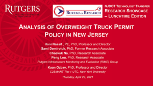
Analysis of Overweight Truck Permit Policy in New Jersey. Dr. Hani Nassif is a professor at Rutgers, The State University of New Jersey, where he has established the Bridge Engineering Program.   Dr. Nassif introduced the study and acknowledged the contribution of the research team that worked on this study and a prior study focused on the impact of freight on pavement and bridge infrastructure.

This research study explored whether New Jersey’s scheduled permit fees for overweight trucks allow NJDOT to recover all or part of the costs of the damage imposed by these vehicles traveling on NJ roads and bridges.

In a previous study, researchers had correlated truck overweight data with damage to bridges and pavements which showed higher rate of deterioration with higher rates of use by overweight trucks. The main question for this study considered whether the permit fees were sufficient to recover the costs incurred on the infrastructure. Then, in light of these findings, what policy recommendations could be made to change permit policies.

Dr. Nassif described various data sources and methods that were used to estimate the costs of damage to roads and bridges caused by overweight vehicles, including six years of data from the NJ Overweight Permit Database, Straight Line Diagrams of the NJ roadway network, GIS and the National Bridge Inventory including bridge location and conditions.

Dr. Nassif also provided an overview of NJ Overweight Permits, explaining the various types, validity, fee schedule and weight rules.  He highlighted the challenges of effectively collecting fees for overweight trucks and use categories for which fees are not adequately collected.   If a truck weighs more than 80,000 lbs., a permit should be obtained. Although, the State issues 100,000 permits each year, 96 percent of overweight trucks are estimated to be running without permits. These are not short hauls; the trip length is, on average, 50 miles.

The study also looked at fee permitting across the country. Each state uses one of three different permit fee structures: a flat fee; an oversize, overweight fee; and a new model which combines oversize, overweight, and mileage. The study included an effort to benchmark New Jersey against other states in terms of its fee structure. NJ is fourth highest in terms of overweight fee structure.  Any revised policy must take into account these higher fees in relation to neighboring states.

Dr. Nassif noted that the study findings can inform discussion of alternative policies on trucking fees.  The State can maintain the same fee schedule, add mileage to the fee calculation, or charge a flat fee. Dr. Nassif noted that it is not the objective of the state to recoup all the damage costs but perhaps to try to have all sectors of the economy pay their share in terms of the damage to the infrastructure. He suggested that, because trucks using more than six axles cause less damage, the use of more axles could be incentivized. Fees in NJ are already high, so an increase may not be feasible. All sectors of the trucking industry should pay their fair share.  There may be greater efficiency and equity in imposing a permit fee structure that collects a greater fee for longer mileage trips.

Dr. Nassif answered several questions following his presentation: 

Q. What would be your recommendation for regulating overweight trucks- to change to a flat fee or a mileage-based fee?
A. A combination of overweight and mileage fees might be most appropriate in NJ for a fair distribution of permit fees. This is similar to neighboring states. The average trip length is 50 miles for a permit. If a truck travels more, the State could add $1 for each additional mile would recoup 80 percent of the damage cost.

Q. Have you considered the cost of compliance in payment of fees for overweight vehicles?
We have been trying to work with the trucking association – we had a couple of workshops with stakeholders from agencies and trucking association – with the overall goal of enhancing the movement of goods. For example, the state could incentivize the use of a larger number of axles by lowering fees for these trucks. Truck weight enforcement is currently inefficient – it’s like chasing “cat and mouse”. Permits are not obtained for most overweight vehicles. Autonomous enforcement using accurate sensors along the road could result in citations and force drivers to get overweight permits. Weigh-in-Motion stations could be used as enforcement stations.

The enforcement needs to be more effective and we need more legislation; this legislation is under consideration in NY. NJ should consider this legislation to generate more revenue, and provide an equal footing for all parts of the trucking industry.

Q. With regional partners working together would we see more compliance?
A. There have been some regional efforts, including the Port Authority of New York and New Jersey calling for harmonizing the permitting process across state lines. New Jersey and New York could take the lead in advancing legislation to create a unified approach from Connecticut to Delaware and Maryland.

A recording of the webinar is available here.

Center for Local Aid Support (CLAS) On-Line Trainings

The FHWA’s Center for Local Aid Support has developed a series of self-paced online training courses for local agencies and tribal communities. The addition of these courses demonstrates the agency’s commitment to empowering transportation professionals with the skills necessary to deploy new innovation that keeps transportation moving into the future.

The courses are conducted 100% online and are on-demand, allowing users to learn at their own pace and on their own time.

The training courses focus on Every Day Counts initiatives such as:

  • Safe Transportation for Every Pedestrian (STEP)
  • Geosynthetic Reinforced Soil – Integrated Bridge System (GRS-IBS)
  • Gravel Roads Construction and Maintenance
  • Construction Inspection of Rockeries
  • Project Bundling: (1) Fundamentals Event, (2) Staging the Bundle Event, and (3) Creating and Contracting the Bundle Event

CLAS will continue to develop training that will keep transportation moving into the future. These courses can be accessed on the CLAS website. Additionally, access to previous and upcoming webinars by CLAS can be found here.

Lunchtime Tech Talk! WEBINAR: Analysis of Local Bus Markets

On October 7, 2020, NJDOT hosted a Lunchtime Tech Talk! Webinar on the Analysis of Local Bus Markets with Deva Deka, Ph.D., Assistant Director, Research, at Rutgers – Alan M. Voorhees Transportation Center, and Susan O’Donnell, Senior Director, Business Analysis and Market Research at NJ TRANSIT. Dr. Deka began the presentation with a general description of the NJ TRANSIT system that operates approximately 250 bus routes throughout New Jersey. Bus riders constitute almost 60 percent of all riders using NJ TRANSIT services, including commuter rail and light rail. For many New Jersey residents, those buses are essential for meeting almost all daily travel needs.

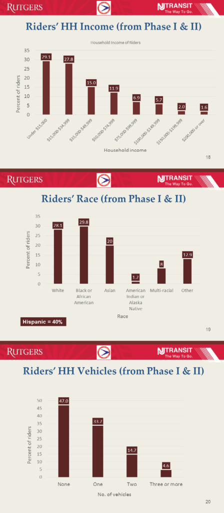
Dr. Deka provided a profile of the demographics of bus users, including household income, race, and vehicle ownership

Dr. Deka provided a profile of the demographics of bus users, including household income, race, and vehicle ownership.

For the past five years, the Alan M. Voorhees Transportation Center of Rutgers University has been conducting onboard surveys of bus riders in different parts of New Jersey for projects funded by the NJDOT Bureau of Research and sponsored by NJ TRANSIT. Dr. Deka, the Principal Investigator for these survey studies, presented the bus survey methodology, and key findings. He described the questionnaire design, survey scheduling, training of surveyors, and the process of data collection, and the post-survey process that has involved data cleaning and weighting, and analysis. Over the five years, the project has generated clean data for over 15,000 riders.

Dr. Deka gave an overview profile of bus rider characteristics and trip characteristics found from the survey research. The survey showed that riders are predominantly Hispanic and/or African-American, lower-income, from households with no car or one car, and dependent on the bus system. The data support the essentiality of bus services for zero-car households and inform analyses of the broader impacts of bus services such as decreases in traffic delays and reductions in greenhouse gas emissions.

In the second half of the presentation, Ms. O’Donnell described the use of the survey data by NJ TRANSIT for planning purposes. The data supports travel demand modeling which replicates existing conditions and predicts future conditions to inform roadway projects and transit projects. This information is shared with New Jersey’s three Metropolitan Planning Organizations, the Port Authority of New York and New Jersey, and the New York Metropolitan Transportation Council. Current data is required in transit grant applications, and contributes to studies related to access to transit, corridors, intermodal systems, and transit oriented development.

To fulfill the agency’s obligations under Title VI of the Civil Rights Act of 1964, NJ TRANSIT uses the data to perform an equity analysis to evaluate the effect of fare changes or service changes on low-income populations and minority populations, and to provide data to help in developing a language assistance plan for Limited English Proficiency populations.

In addition, NJ TRANSIT uses the data when working with advertisers that want to target their message efficiently to specific demographic groups.

The agency’s Newark Bus System Redesign Project will use the data collected in fall 2019 to align and modify bus routes and explore service to new areas. This is the first, and largest, of multiple systems to be evaluated to bring the agency’s entire bus system up to date.

In closing, Ms. O’Donnell presented an update on bus use during the pandemic based on surveys given during April and June. The data shows how important the bus system has been to essential workers.

Following the presentation, the Dr. Deka and Ms. O’Donnell responded to questions asked through the chat feature:

Q. What was the number of questions asked on the survey and what incentives were offered?
A. The survey comprised about 30 questions. Incentives helped increase interest in the surveys and respondents had a chance of winning 1 of 5 $100 gift cards.

Q. Did you consider using IPads rather than paper-based intercept surveys?
A. Dr. Deka noted that they did consider them, but use of IPads limits the number of surveys that can be collected at one time. The surveyor has to stay with the individual using the IPad, and cannot approach other riders at the same time, limiting the efficiency of the survey-taker. Dr. Deka also referenced a Mineta Transportation Institute report that compared data quality and costs for different approaches to on-board transit passenger surveys that found efficiencies with the paper-intercept approach for bus users. Ms.O’Donnell noted that this technology might work at a station or on a platform because a number of surveyors can be located in the same place but is difficult to use on a crowded bus. During the pandemic, IPads probably could not be used due to safety concerns with touching and handling equipment.

Q. What are typical variables used to weight the data to the total ridership?
A. The sample is weighted by direction of the bus, time of day, and the run. A trip is from an origin to the destination and all trips combined is a run. They do not weight the sample by demographic variables or geography because they do not have solid information on the total transit user “universe” population related to these variables.

Q. Did you compare rider survey results by types of service area?
A. No. While there are some suburban routes if you segment or categorize by origins, such as Morristown, almost all routes are generally very urban. It would be possible to use the data to compare by counties.

Q. What is the delay imposed by traffic congestion on buses?
A. Traffic impacts have been an issue that has been looked at by traffic engineers at Rutgers – CAIT some years ago. They collected data traffic signal timings at intersections that the bus traveled through and applied VISSIM for simulations. Dr. Deka said that he could connect anyone interested with the detailed technical methods that the researchers used on that traffic impact study, if they’re interested.

The presentation given by Dr. Deka and Ms. O'Donnell can be downloaded here

A recording of the webinar is also available (see right).

Lunchtime Tech Talk! WEBINAR: Evaluation of Precast Concrete Pavement Systems and State Specifications

On June 10, 2020, the NJDOT Bureau of Research hosted a Lunchtime Tech Talk! Webinar on "Evaluation of Precast Concrete Pavement Systems and State Specifications.” Dr. Yusuf Mehta, Director of Rowan University’s Center for Research and Education in Advanced Transportation Engineering Systems (CREATEs), introduced the presentation and acknowledged the contributions of individuals and other state DOTs to the research effort.  Dr. Daniel Offenbacker began the presentation with a description of the research study performed for NJDOT to identify, evaluate, and compare precast pavement systems, specifications, and practices currently in use for Precast Concrete Pavement (PCP). The study included an extensive literature review and surveys with Subject Matter Experts from various state DOTs that have experience with precast concrete pavement rehabilitations.

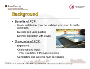
Dr. Offenbacker discussed the benefits and drawbacks of Precast Concrete Pavements.

Rigid pavements play an important role in highway infrastructure, primarily in regions with high traffic density such as New Jersey. NJDOT is continuously exploring innovative pavement rehabilitation strategies, such as Precast Concrete Pavement (PCP), that allow for faster and more durable rehabilitation of rigid pavements. Precast concrete is cast off-site to specifications and installed to match a particular location. Dr Offenbacker noted the benefits of precast concrete systems including quick installation that limits the duration of road closure and requires minimal interaction with drivers. The material is durable and long-lasting. Drawbacks include the high cost, challenges to installation requiring tight specifications, and limited capability among contractors and systems.

The researchers surveyed 17 states and followed up with 8 states that are using PCP systems. Other states shared experiences with systems in use, standards for manufacture and installation, permitting of new systems, and experiences with installation and performance. Eight different state specifications were identified that addressed panel fabrication, bedding and grout stabilization, installation tolerances, and encasement grout.

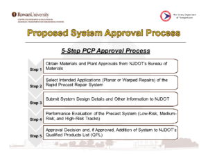
The research led to the conclusion that installation is critical to PCP performance. Failure is generally due to misalignment or poor leveling. Dr. Offenbacker described a proposed five-step system approval process to be used in New Jersey for acceptance of newly-developed precast pavements. The approval system included materials and slab approval, demonstration of system installation, and proof of performance. Recommendations included use of documented experiences from other states in establishing specifications and exploring development of a generic PCP system for New Jersey.

The research resulted in recommendations for a Precast Concrete Pavement approval process for use in New Jersey

Dr. Offenbacker noted the need for future work to investigate the long-term performance of PCP systems, to prepare a life cycle cost analysis to quantify the economic benefits, to assess the usefulness of intermittent precast systems in light of surrounding pavement deterioration, and to develop a training platform for contractors to insure proper installation.

Following the presentation, participants posed questions via the chat feature. Responding to a question about the use of planar vs. non-planar slabs, Dr. Offenbacker noted that the existing conditions of the roadway would determine which slab would be used to match the existing structure.

A participant asked if there was any criteria for choosing between rapid-set concrete and PCP. Dr. Offenbacker responded that there was no criteria yet for when one would choose one over the other.

A participant asked what Dr. Offenbacker considered the key takeaway from the surveys. He responded that installation was the key consideration. He emphasized the need to understand the economic benefits of PCP, which are starting to outweigh the benefits of other rehab techniques such as rapid-set.

In response to a question about training needed, Dr. Offenbacker noted that training is needed in the specific systems. California requires each contractor to go through a certification process if they want to use precast pavement systems on a regular basis.

A participant asked if deterioration of slabs adjacent to a replacement slab was due to the replacement slab. Dr. Offenbacker replied that the replacement slab would not cause deterioration if installed properly. The roadway may be deteriorating incrementally.

A participant asked if the Federal Highway Administration (FHWA) provided input on QA/QC for underslab grouting and grouting dowel bar slots. Dr. Offenbacker responded that there are thorough specifications for these elements and they are available in the final report.

In response to a question about whether there is a maximum and minimum size for PCPs and how that correlates to performance, Dr. Offenbacker noted that this has not been explored well yet. The typical length is 15 feet.

The presentation given by Dr. Mehta and Dr. Offenbacker can be downloaded here.
For more information about the research study, please access the final report and technical brief here.

For more information about research at Rowan University's CREATES, click here.
A recording of the presentation is also available here (or see right).

Lunchtime Tech Talk! WEBINAR: Dredging, Dredged Material Management and the NJ Marine Transportation System

On May 12, 2020, the NJDOT Bureau of Research hosted a Lunchtime Tech Talk! Webinar on "Dredging, Dredged Material Management and the New Jersey Marine Transportation System.” W. Scott Douglas, Dredging Program Manager in NJDOT’s Office of Maritime Resources (OMR), discussed the dredging process, management of dredged material, OMR’s asset management system, and dredging case studies.

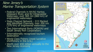
Mr. Douglas discussed the extent of New Jersey's Marine Transportation System, and its significance to the local, and larger economy.

Mr. Douglas described the New Jersey Marine Transportation System (MTS) that includes all infrastructure and equipment that connects land-based transportation assets to navigable water. The MTS supports a $50 billion industry that encompasses international and domestic freight, commercial fishing, recreational boating, travel and tourism, marine trades and ferries. NJDOT is directly responsible for maintaining some 200 of the 600 nautical miles of engineered waterways that provide safe navigation pathways to and from the shore-based infrastructure, and provides dredged material management services for another 150 nautical miles of Federal waterway. Since Superstorm Sandy, OMR is the State’s lead agency for these responsibilities, providing planning, design, procurement and construction services and coordinating the State’s waterway emergency response.
The system is divided into three regions: the New Jersey/New York Harbor (the third largest port in the country), the Delaware River, and the Atlantic Shore where NJDOT takes a larger role. Much of their work involves managing clean dredge materials in shallow draft areas where there is little land on which to place the dredged material. Mr. Douglas described the various aspects of the dredging process including bathymetric surveys, sediment sampling and analysis, and permitting, and went on to explain uses of dredged material.
As a natural part of the aquatic ecosystem, sediment is a resource. The Office of Maritime Resources works to reuse the material in various ways depending on the nature and composition of the sediment. Mr. Douglas offered several examples of reuse such as construction fill, beach replenishment, landfill capping, and brownfield redevelopment. The OMR is exploring the use of sediment to increase shoreline resiliency through marsh and dune restoration and other shoreline stabilization techniques, island creation, dredged hole replacement, and habitat creation.

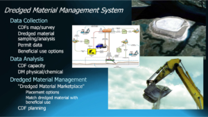
The talk highlighted several facets of collecting, tracking, and dispersing dredged materials.

Mr. Douglas discussed his agency’s Maritime Asset Management tools developed to evaluate cost, conditions, and to help prioritize the Office’s work. Their Waterway Linear Segmentation database, comparable to the roadway Straight Line Diagrams, is a first in the nation for maritime asset management. OMR is assembling a dredged material database. Deployment of these tools is anticipated later this year. OMR’s Maritime Asset Management Systems comprises these two tools and produces plans based on current and future conditions, cost, and availability of dredge system management. The output is similar to the asset management reports used by highway and bridge engineers to assist management in decisionmaking.

Successes of the state’s channel dredging program include 54 channels cleared and 45 nautical miles of waterway opened. Mr. Douglas highlighted three dredging case studies including projects in the Port Jersey Channel, Shark River, and Upper Barnegat Bay. In 2020, OMR has four ongoing projects and four planned projects to open a total of 25 channels.

Participants posed questions via the Q&A feature. Mr. Douglas was asked what quality controls are in place before dredged material is moved. He noted that New Jersey has one of the most stringent systems in place in the country. NJDEP has a list of contaminants related to locations. They test both the sediment before it is moved, and the water, and a mixture of sediment water. If the material is stabilized and placed upland, it is exposed to lab testing and leachate tests on site. Another participant asked if dredging stirs up contaminants. Mr. Douglas replied that it can, and that the rigorous testing is designed to address the possibility. He noted the distinction between navigation dredging to clear a channel and environmental dredging conducted to clean contaminants from a waterway.

In response to a question concerning locations of island creation, Mr. Douglas stated that a group led by the US Fish & Wildlife Service is looking into potentially creating islands in Barnegat Bay.

A participant asked if dredged material could be used in new embankments and walls that NJDOT is building throughout the state. Mr. Douglas responded that the biggest barrier is cost. Straight fill is less expensive and easier to schedule; timing of highway projects with maritime projects has been difficult.

A participant wondered how the required dredge depth is verified once it is completed? Dredge depth is determined before dredging begins. Generally, channel depth has been determined for the entire state. Usually the depth changes only if conditions change, such as would be required with the introduction of larger vessels needing access to ports.

In response to a question concerning work continuing during the COVID-19 outbreak, Mr. Douglas noted that work is continuing and inspectors are on site every day following appropriate and requisite protocols.

The presentation given by Mr. Douglas can be downloaded here.

A recording of the webinar is available here, (or see right).

FHWA’s Ray Murphy Presents EDC-5 Weather-Responsive Management Strategies

On April 14, 2020, the NJDOT Bureau of Research hosted a Lunchtime Tech Talk! webinar on "EDC-5 Weather-Responsive Management Strategies." This event featured a presentation by Ray Murphy, ITS Specialist with the FHWA's Resource Center. Under Round 5 of the Every Day Counts (EDC) program, FHWA promotes Weather-Responsive Management Strategies (WRMS) to manage traffic and road maintenance during inclement weather to improve safety and reliability, and minimize environmental impacts associated with weather events. Weather affects: traffic safety, with 21 percent of the nearly 6 million roadway crashes in the past decade related to weather; mobility, resulting in reduced efficiency and productivity; and environmental impacts on watersheds, air quality, and infrastructure.

Mr. Murphy provided examples of weather responsive practices being tried by state DOTs, including an advanced traveler information notification deployed by Iowa DOT.

Mr. Murphy provided examples of weather responsive practices being tried by state DOTs, including an advanced traveler information notification deployed by Iowa DOT.

Mr. Murphy described the prior-round, EDC-4 innovation, Road Weather Management – Weather-Savvy Roads, that formed the basis for this EDC-5 initiative. The innovation promoted data collection including Pathfinder, a collaboration between the National Weather Service, state DOTs, and state support contractors to provide weather information and forecasts, and Integrating Mobile Observations (IMO) that collects weather and road condition data from instruments on agency fleet trucks.

Through WRMS, FHWA promotes the use of mobile data to support decision making. Benefits to agencies include improved safety, system performance and operations, and reduced costs and environmental impacts. Agencies can use Weather Responsive Management Systems to address diverse internal needs such as staffing, material use, and route optimization, and condition and performance reporting. Data sources include transportation agency fleets, private vehicles, third party entities, agency operators, road users and infrastructure. Some data is collected by in-vehicle sensors, video and camera images, and automatic vehicle location. Other data sources include fixed Roadway Information System (RWIS), National Weather Service, reports from road users and operators, mobile observations and connected vehicle data, among others.

The traveling public benefits through safer pre-trip and real-time route decision making based on enhanced traveler information, roadside messaging, variable speed limits, and road lane closures or restrictions. Unified, localized, and more accurate messaging gives the public increased confidence in the messaging and the agency.

Mr. Murphy addressed some common challenges that agencies face in adopting this innovation, such as a lack of connectivity in remote areas, the need for buy-in from agency leadership and from road crews, hesitance to adopt the innovation, and funding.

Mr. Murphy cited some of work that NJ DOT has accomplished in the field of Weather Responsive Management Strategies.

Mr. Murphy highlighted recent initiatives undertaken by NJDOT related to Weather Responsive Management Strategies that have been funded in part through FHWA innovation grants.

He noted that the State Transportation Innovation Council (STIC) Incentive Program and STIC Accelerated Innovation Deployment (AID) grants can help fund implementation of these technologies. NJDOT received a STIC incentive funding grant to support pilot testing of technology used by the Safety Service Patrols. NJDOT was also awarded an AID Grant from FHWA to support a weather savvy roads pilot program, installing video camera dashboards and sensors onto NJDOT maintenance trucks and safety service patrol vehicles to collect streaming video and weather / pavement information to support road weather management throughout the state.

Webinar participants had an opportunity to pose questions of Mr. Murphy. One participant asked about possible resistance to installation of automatic vehicle locators due to privacy concerns. Mr. Murphy noted that agencies must operate openly and inclusively when implementing this technology. Training and education can help users become more accepting of the technology.

A participant asked about the use of IMO data versus information gathered from a public entity such as WAZE. Mr. Murphy responded that the agency receives the IMO data directly and can oversee the accuracy of the data, but that information should come from multiple sources to create a robust dataset.

When asked what agencies consider the biggest challenges, and what arguments can be used to support this innovation, Mr. Murphy responded that funding is always a concern but that buy-in is often the larger issue. He emphasized the need for a champion who can demonstrate the benefits of the strategies through performance measures.

When asked if specific applications of WRMS were being considered for EDC-6, Mr. Murphy responded that various innovative practices were being considered and no decisions had been made yet.

A participant asked if these systems can be adapted to rockfall data. Mr. Murphy noted that visibility apps used with dust storms or fire events could be adapted for other weather events.

Mr. Murphy’s presentation offered several examples of DOTs nationwide employing these strategies. A participant asked if any states are quantifying the benefits of WRMS implementation. Mr. Murphy offered that Caltrans is one agency.

The presentation given by Mr. Murphy can be downloaded here.

More information on this innovation is available on the FHWA Weather Responsive Management Systems resources page.

A recording of the webinar is available here, (also to the right).