Traffic Incident Management (TIM) programs help first responders and traffic operators to better understand and coordinate roadway incidents. As part of the sixth round of the Federal Highway Administration’s (FHWA) Every Day Counts (EDC) initiative, the agency is promoting innovative practice in this area through NextGen TIM. These practices and procedures can advance safety, increase travel reliability, and improve agency operations by engaging with new technologies and trainings. For example, sensors and crowdsourced data can help traffic agencies better detect incidents and decrease response times. Drones, or Unmanned Aerial Systems (UAS) can help transportation agencies and first responders better understand the incident scene and speed the resumption of traffic flow. The NextGen TIM initiative is an effort to improve traffic incident management through technological innovation and standardized operating procedures. NextGen TIM technologies and practices are currently being used in the Delaware Valley to increase real-time situational awareness and ensure maximum safety at the scene of an incident.
Regional Integrated Multimodal Information Sharing (RIMIS)

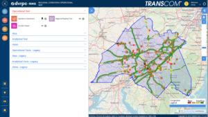
The RIMIS Operational Tool gives a system-wide overview of traffic operations, such as incidents, traffic flow, and construction alerts, courtesy DVRPC
Currently, transportation departments in the region use the TRANSCOM traffic monitoring platform to supervise incidents. The Delaware Valley Planning Commission (DVRPC)’s version of this platform is called RIMIS, or Regional Integrated Multimodal Information Sharing. Because DVRPC is a Metropolitan Planning Organization (MPO) that spans both sides of the Delaware River, its reach includes sections of New Jersey and Pennsylvania—broadly, the greater Philadelphia area. In this region, with overlapping municipal, state, and regional jurisdictions, communication and coordination could be difficult. According to Christopher King, Manager of DVRPC’s Office of Transportation Operations Management, before RIMIS, incident notifications were commonly communicated through phone calls.
Area transportation officials recognized the need for a coordinated platform where information could be shared back and forth. Instead of slow, one-to-one incident notifications, this new, decentralized platform would present a “big picture” perspective of a traffic incident’s impacts on the regional transportation network. The concept was to create a regional centralized information location for traffic operators and first responders to view the traffic status on area roads, and understand, quickly and reliably, where an incident has occurred. Local agencies could access the platform to better understand incident conditions.

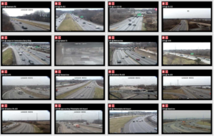
The RIMIS Video Wall allows for real-time roadway monitoring for first responders and traffic operations personnel, courtesy DVRPC
RIMIS was first developed nearly 20 years ago, and has proved to be invaluable as a resource. Participants supply data, such as video feeds and traffic updates, which is then aggregated to update other members. These agencies include PennDOT, NJDOT, SEPTA, and NJ TRANSIT. Member agencies and municipalities, such as Bedminster Township, PA, can take advantage of the operations database, with live and historical traffic flow and incident data, a situational map which geographically represents traffic levels and incidents across the region, and a video wall of roads in the DVRPC area with live camera feeds.
As an example, Mr. King showed a municipal fire department participating in RIMIS, that, once alerted that a collision has occurred, can access the platform’s interactive map, live video feeds, and information on planned interruptions, to better understand the scene before arriving there. The RIMIS platform gives context to first responders on route to an incident, provides a broader view for traffic operations dispatchers managing a disruption, and also assists transportation planners looking for data on how to improve a high-collision roadway.
Interactive Detour Route Mapping (IDRuM)
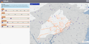
Another TIM tool DVRPC provides is the Interactive Detour Route Mapping (IDRuM) feature, a web application that consolidates established Emergency Detour Routes as a resource for traffic operations personnel, first responders, and transportation planners and engineers.
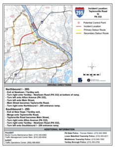
If, for example, an incident has occurred on a certain segment of I-295 in Bucks County, then the Primary Detour Route would involve taking Taylorsville Road south and turning right on State Route 322 to rejoin the highway, while the Secondary Detour Route would take a similar maneuver going north. This information can be easily accessed in both interactive and PDF formats on the IDRuM mapping site.
DVRPC is currently working to integrate NJDOT’s designated Detour Routes into the GIS map for the area east of the Delaware. The data has been uploaded, but is still in beta testing.
NextGen TIM
Mr. King says that a chief focus of NextGen TIM is to expand services such as RIMIS and IDRuM to more localities and arterial routes, as well as to ensure that all first responders are trained in the most up-to-date TIM techniques, such as how to position their vehicles for maximum safety on an active roadway.
During the second round of the Every Day Counts Initiative (EDC-2, 2013-2014), a TIM process and training program was established under the SHRP2, or the second Strategic Highway Research Program. This laid the groundwork for the current TIM training and organizational infrastructure, which is NJTIM in the Garden State. This consortium, spearheaded by NJDOT, provides resources and trainings to teach best practices to first responders across the state. NJDOT and the New Jersey State Police (NJSP) partner together to promote trainings and coordinate highway emergency response. To learn more about NJDOT’s efforts with regards to partnering with NJSP on crash data consolidation, using Unmanned Aerial Systems for incident analysis, and other aspects of the initiative, please visit NJDOT Tech Transfer’s NextGen TIM page.
Resources
Delaware Valley Regional Planning Commission. Interactive Detour Route Mapping (IDRuM). https://www.dvrpc.org/transportation/tsmo/idrum
Delaware Valley Regional Planning Commission. Regional Integrated Multimodal Information Sharing (RIMIS). https://www.dvrpc.org/Transportation/TSMO/RIMIS/
New Jersey Department of Transportation. Statewide Traffic Incident Management Program. https://www.nj.gov/transportation/commuter/motoristassistance/stimp.shtm
New Jersey Traffic Incident Management. Traffic Incident Management Resource Portal. http://www.njtim.org/NJTIM/


