NJDOT’s “Weather Savvy Roads” System Receives 2021 Outstanding Project Award from ITS-NJ

The Intelligent Transportation Society of New Jersey (ITS-NJ) recognizes outstanding projects or programs that employ or advance ITS technologies. This year NJDOT’s “Weather Savvy Roads” system, also known as the Mobile RWIS effort, received its 2021 Outstanding Project Award.

NJDOT’s Weather Savvy Roads Program was recently recognized by the Intelligent Transportation Society of New Jersey

NJDOT’s Weather Savvy Roads (WSR) program started with NJDOT’s Mobility Division applying for and receiving NJ’s first federal Accelerated Innovation Deployment (AID) grant.  The concept was to procure and install mobile RWIS devices and dash cameras in 23 DOT snow-fighting vehicles statewide to view real time conditions and guide decisions for allocation of resources during a winter event.

The team is comprised of staff from NJDOT Mobility, NJDOT Operations, the NJIT ITS Resource Center, and technical partners from Vaisala and EAI.  NJIT created a web-based platform where users could view a statewide map and data from the RWIS devices and video from the CCTV6 in real time.

The WSR project was also designed to continue NJDOT’s investigation into cellular strength along NJDOT’s road network. This effort was first evaluated during NJ STIC Incentive grant funded program using iCone devices on SSP trucks. Utilizing a cellular router carrying FIRSTNET cellular capability, the technical team at NJIT is evaluating the strength of this first responder-only focused cellular system to see the various levels of signal strength. The project has shown tremendous benefits after just one winter season with staff across multiple levels of the Department utilizing the web platform to make better informed decisions about staffing and contractor use.

To learn more about the project, click on the NJ Innovative Initiatives, Weather Responsive Management Strategies page, or watch a presentation to the NJ STIC by Sal Cowan, Senior Director of Mobility at NJDOT about the equipment installation and web interface efforts taken for the pilot project.

See the FHWA’s Innovation Spotlight video on Road Weather Management: Weather Savvy Roads.

Developing Next Generation Traffic Incident Management in the Delaware Valley

Traffic Incident Management (TIM) programs help first responders and traffic operators to better understand and coordinate roadway incidents. As part of the sixth round of the Federal Highway Administration’s (FHWA) Every Day Counts (EDC) initiative, the agency is promoting innovative practice in this area through NextGen TIM. These practices and procedures can advance safety, increase travel reliability, and improve agency operations by engaging with new technologies and trainings. For example, sensors and crowdsourced data can help traffic agencies better detect incidents and decrease response times. Drones, or Unmanned Aerial Systems (UAS) can help transportation agencies and first responders better understand the incident scene and speed the resumption of traffic flow. The NextGen TIM initiative is an effort to improve traffic incident management through technological innovation and standardized operating procedures. NextGen TIM technologies and practices are currently being used in the Delaware Valley to increase real-time situational awareness and ensure maximum safety at the scene of an incident.

Regional Integrated Multimodal Information Sharing (RIMIS)
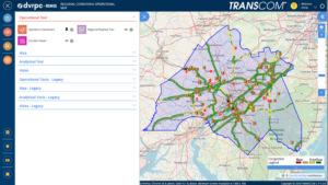
Image of RIMIS Operational Tool, which is a map of the DVRPC region, with Philadelphia at the center, and portions of New Jersey to the east, and Pennsylvania to the West, highway routes are marked in green and yellow, yellow denoting slower than usual operations, orange construction worker signals denote construction along the corridor, many of them are clustered aroudn Philadelphia.

The RIMIS Operational Tool gives a system-wide overview of traffic operations, such as incidents, traffic flow, and construction alerts, courtesy DVRPC

Currently, transportation departments in the region use the TRANSCOM traffic monitoring platform to supervise incidents. The Delaware Valley Planning Commission (DVRPC)’s version of this platform is called RIMIS, or Regional Integrated Multimodal Information Sharing. Because DVRPC is a Metropolitan Planning Organization (MPO) that spans both sides of the Delaware River, its reach includes sections of New Jersey and Pennsylvania—broadly, the greater Philadelphia area. In this region, with overlapping municipal, state, and regional jurisdictions, communication and coordination could be difficult. According to Christopher King, Manager of DVRPC’s Office of Transportation Operations Management, before RIMIS, incident notifications were commonly communicated through phone calls.

Area transportation officials recognized the need for a coordinated platform where information could be shared back and forth. Instead of slow, one-to-one incident notifications, this new, decentralized platform would present a “big picture” perspective of a traffic incident’s impacts on the regional transportation network. The concept was to create a regional centralized information location for traffic operators and first responders to view the traffic status on area roads, and understand, quickly and reliably, where an incident has occurred. Local agencies could access the platform to better understand incident conditions.
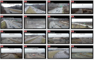
Image of 16 video feeds, each of a different stretch of highway, a video wall for traffic operations monitoring.

The RIMIS Video Wall allows for real-time roadway monitoring for first responders and traffic operations personnel, courtesy DVRPC

RIMIS was first developed nearly 20 years ago, and has proved to be invaluable as a resource. Participants supply data, such as video feeds and traffic updates, which is then aggregated to update other members. These agencies include PennDOT, NJDOT, SEPTA, and NJ TRANSIT. Member agencies and municipalities, such as Bedminster Township, PA, can take advantage of the operations database, with live and historical traffic flow and incident data, a situational map which geographically represents traffic levels and incidents across the region, and a video wall of roads in the DVRPC area with live camera feeds.

As an example, Mr. King showed a municipal fire department participating in RIMIS, that, once alerted that a collision has occurred, can access the platform’s interactive map, live video feeds, and information on planned interruptions, to better understand the scene before arriving there. The RIMIS platform gives context to first responders on route to an incident, provides a broader view for traffic operations dispatchers managing a disruption, and also assists transportation planners looking for data on how to improve a high-collision roadway.

Interactive Detour Route Mapping (IDRuM)
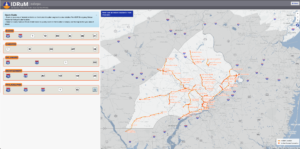
Image of a map of Philadelphia, with highway routes in orange, delineated into sections. Each section, when clicked on, shows two detour routes in the event of a serious incident.

IDRuM is a detour resource for rerouting traffic after major incidents, courtesy DVRPC

Another TIM tool DVRPC provides is the Interactive Detour Route Mapping (IDRuM) feature, a web application that consolidates established Emergency Detour Routes as a resource for traffic operations personnel, first responders, and transportation planners and engineers.

If, for example, an incident has occurred on a certain segment of I-295 in Bucks County, then the Primary Detour Route would involve taking Taylorsville Road south and turning right on State Route 322 to rejoin the highway, while the Secondary Detour Route would take a similar maneuver going north. This information can be easily accessed in both interactive and PDF formats on the IDRuM mapping site.
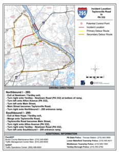
Image of two detour routes from I-295, one goes on a road to the north and then southeast to rejoin the highway, the other to the south and then northwest.

DVRPC is currently beta testing detour routes from NJDOT for the IDRuM platform, courtesy DVRPC

DVRPC is currently working to integrate NJDOT’s designated Detour Routes into the GIS map for the area east of the Delaware. The data has been uploaded, but is still in beta testing.

NextGen TIM

Mr. King says that a chief focus of NextGen TIM is to expand services such as RIMIS and IDRuM to more localities and arterial routes, as well as to ensure that all first responders are trained in the most up-to-date TIM techniques, such as how to position their vehicles for maximum safety on an active roadway.

During the second round of the Every Day Counts Initiative (EDC-2, 2013-2014),  a TIM process and training program was established under the  SHRP2, or the second Strategic Highway Research Program. This laid the groundwork for the current TIM training and organizational infrastructure, which is NJTIM in the Garden State. This consortium, spearheaded by NJDOT, provides resources and trainings to teach best practices to first responders across the state. NJDOT and the New Jersey State Police (NJSP) partner together to promote trainings and coordinate highway emergency response. To learn more about NJDOT’s efforts with regards to partnering with NJSP on crash data consolidation, using Unmanned Aerial Systems for incident analysis, and other aspects of the initiative, please visit NJDOT Tech Transfer’s NextGen TIM page.


Resources

Delaware Valley Regional Planning Commission. Interactive Detour Route Mapping (IDRuM). https://www.dvrpc.org/transportation/tsmo/idrum

Delaware Valley Regional Planning Commission. Regional Integrated Multimodal Information Sharing (RIMIS). https://www.dvrpc.org/Transportation/TSMO/RIMIS/

New Jersey Department of Transportation. Statewide Traffic Incident Management Program. https://www.nj.gov/transportation/commuter/motoristassistance/stimp.shtm

New Jersey Traffic Incident Management. Traffic Incident Management Resource Portal. http://www.njtim.org/NJTIM/
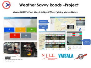
Image is of two construction workers in neon vests sitting on a platform above freshly poured concrete, which they are working on treating.

FHWA Issues EDC-5 Final Report and EDC-6 Baseline Report

The FHWA has issued a Final Report for Round 5 of the Every Day Counts Initiative (EDC-5), and a Baseline Report for EDC-6. The reports demonstrate completed and preliminary progress on implementation of selected innovations, such as Crowdsourcing for Advancing Operations and e-Ticketing.

Since the advent of the program in 2009, FHWA has worked to standardize innovation as an industry practice. For EDC-5, which took place from 2019-2020, FHWA reports that state agencies accomplished 98 percent of their implementation goalsthe highest success rate since EDC began. The vast majority of innovative ideas have been demonstrated, assessed (in preparation for deployment), or institutionalized by the state agency.

NJDOT is committed to supporting this initiative, which is administered on a state-by-state basis. The New Jersey Strategic Innovation Council (NJSTIC), is comprised of various stakeholders, including representatives from NJDOT, universities, municipalities, Metropolitan Planning Organizations, and counties. NJ STIC meets quarterly to discuss new innovations and progress on initiatives. More information about NJ STIC can be found here.

To learn more about past projects and progress on current EDC initiatives in the region, please visit our Innovative Initiatives page.

The two reports may be viewed below, or on FHWA's website: EDC-5 Final Report, EDC-6 Baseline Report.

Image Reads: Every Day Counts: Innovation for a Nation on the Move, EDC-5 Final Report, April 2021

Image Reads: Every Day Counts, Innovation for a Nation on the Move, EDC-6 Summit Summary and Baseline Report, May 2021

FHWA’s Ray Murphy Presents EDC-5 Weather-Responsive Management Strategies

On April 14, 2020, the NJDOT Bureau of Research hosted a Lunchtime Tech Talk! webinar on "EDC-5 Weather-Responsive Management Strategies." This event featured a presentation by Ray Murphy, ITS Specialist with the FHWA's Resource Center. Under Round 5 of the Every Day Counts (EDC) program, FHWA promotes Weather-Responsive Management Strategies (WRMS) to manage traffic and road maintenance during inclement weather to improve safety and reliability, and minimize environmental impacts associated with weather events. Weather affects: traffic safety, with 21 percent of the nearly 6 million roadway crashes in the past decade related to weather; mobility, resulting in reduced efficiency and productivity; and environmental impacts on watersheds, air quality, and infrastructure.

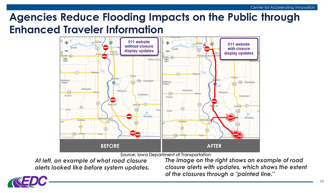
Mr. Murphy provided examples of weather responsive practices being tried by state DOTs, including an advanced traveler information notification deployed by Iowa DOT.

Mr. Murphy provided examples of weather responsive practices being tried by state DOTs, including an advanced traveler information notification deployed by Iowa DOT.

Mr. Murphy described the prior-round, EDC-4 innovation, Road Weather Management – Weather-Savvy Roads, that formed the basis for this EDC-5 initiative. The innovation promoted data collection including Pathfinder, a collaboration between the National Weather Service, state DOTs, and state support contractors to provide weather information and forecasts, and Integrating Mobile Observations (IMO) that collects weather and road condition data from instruments on agency fleet trucks.

Through WRMS, FHWA promotes the use of mobile data to support decision making. Benefits to agencies include improved safety, system performance and operations, and reduced costs and environmental impacts. Agencies can use Weather Responsive Management Systems to address diverse internal needs such as staffing, material use, and route optimization, and condition and performance reporting. Data sources include transportation agency fleets, private vehicles, third party entities, agency operators, road users and infrastructure. Some data is collected by in-vehicle sensors, video and camera images, and automatic vehicle location. Other data sources include fixed Roadway Information System (RWIS), National Weather Service, reports from road users and operators, mobile observations and connected vehicle data, among others.

The traveling public benefits through safer pre-trip and real-time route decision making based on enhanced traveler information, roadside messaging, variable speed limits, and road lane closures or restrictions. Unified, localized, and more accurate messaging gives the public increased confidence in the messaging and the agency.

Mr. Murphy addressed some common challenges that agencies face in adopting this innovation, such as a lack of connectivity in remote areas, the need for buy-in from agency leadership and from road crews, hesitance to adopt the innovation, and funding.

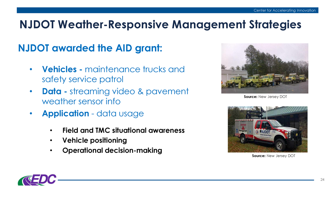
Mr. Murphy cited some of work that NJ DOT has accomplished in the field of Weather Responsive Management Strategies.

Mr. Murphy highlighted recent initiatives undertaken by NJDOT related to Weather Responsive Management Strategies that have been funded in part through FHWA innovation grants.

He noted that the State Transportation Innovation Council (STIC) Incentive Program and STIC Accelerated Innovation Deployment (AID) grants can help fund implementation of these technologies. NJDOT received a STIC incentive funding grant to support pilot testing of technology used by the Safety Service Patrols. NJDOT was also awarded an AID Grant from FHWA to support a weather savvy roads pilot program, installing video camera dashboards and sensors onto NJDOT maintenance trucks and safety service patrol vehicles to collect streaming video and weather / pavement information to support road weather management throughout the state.

Webinar participants had an opportunity to pose questions of Mr. Murphy. One participant asked about possible resistance to installation of automatic vehicle locators due to privacy concerns. Mr. Murphy noted that agencies must operate openly and inclusively when implementing this technology. Training and education can help users become more accepting of the technology.

A participant asked about the use of IMO data versus information gathered from a public entity such as WAZE. Mr. Murphy responded that the agency receives the IMO data directly and can oversee the accuracy of the data, but that information should come from multiple sources to create a robust dataset.

When asked what agencies consider the biggest challenges, and what arguments can be used to support this innovation, Mr. Murphy responded that funding is always a concern but that buy-in is often the larger issue. He emphasized the need for a champion who can demonstrate the benefits of the strategies through performance measures.

When asked if specific applications of WRMS were being considered for EDC-6, Mr. Murphy responded that various innovative practices were being considered and no decisions had been made yet.

A participant asked if these systems can be adapted to rockfall data. Mr. Murphy noted that visibility apps used with dust storms or fire events could be adapted for other weather events.

Mr. Murphy’s presentation offered several examples of DOTs nationwide employing these strategies. A participant asked if any states are quantifying the benefits of WRMS implementation. Mr. Murphy offered that Caltrans is one agency.

The presentation given by Mr. Murphy can be downloaded here.

More information on this innovation is available on the FHWA Weather Responsive Management Systems resources page.

A recording of the webinar is available here, (also to the right).

EDC-5 CHANGE: Collaborative Hydraulics (2.0) Advancing to the Next Generation of Engineering

On August 6th the NJDOT Bureau of Research hosted a Lunchtime Tech Talk! on “EDC-5 CHANGE: Collaborative Hydraulics (2.0) Advancing to the Next Generation of Engineering.” This event featured a presentation by Dr. Eric Brown, Senior Hydraulic Engineer, Geotechnical & Hydraulic Engineering, from the FHWA’s Resource Center. Under Round 5 of the Every Day Counts (EDC) program, Collaborative Hydraulics (2.0) provides the next-generation hydraulic modeling tools to improve the understanding of complex interactions between river or coastal environments and transportation assets, enabling better design, enhanced communication, and more efficient project delivery.

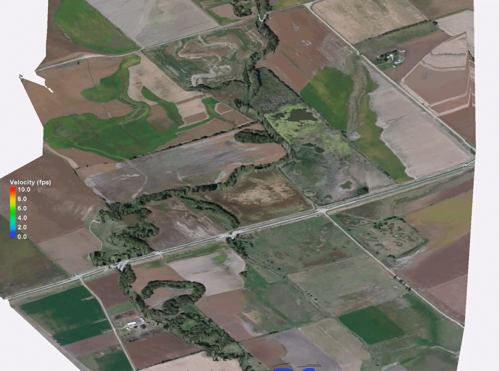
Example of 2D Modeling Results. Image credit: Nebraska DOT

Dr. Brown began his presentation by providing a background of the discipline of hydraulic engineering and its place within the Federal Highway Administration (FHWA). This included an overview of the hydraulic engineering team at FHWA, including specializations and technical expertise. The National Hydraulic Team provides its FHWA offices nationwide with assistance in the hydraulic discipline. This includes interpreting policies, publications, advancing new technologies, and recommending guidance when division offices are faced with unusual drainage problems.

Through the EDC-5 Initiative, FHWA has begun implementing its next-generation hydraulic modeling tools. Thanks to recent advances in computer hardware, modeling software, and data collection, 2-D modeling has become very efficient, intuitive, and accessible to engineers and designers. Not only are 2-D models more accurate, but they can be communicated easily to others in 3-D form.

Dr. Brown then introduced various tools that showcase FHWA’s capabilities. These included channel analysis, Weir analysis, detention basin analysis, riprap design, culvert assessments, and bridge scour analyses. These tools were then further highlighted through the hydraulic models FHWA utilizes with their newest software. These models were used to determine elevation, shear stresses, and flow velocities to assist with construction decisions.  Several other software were also highlighted, such as the US Army Corps of Engineers Hydrologic Engineering Center’s River Analysis System. This software allows the user to perform one-dimensional steady flow, one and two-dimensional unsteady flow calculations, sediment transport/mobile bed computations, and water temperature/water quality modeling. In particular, the ability for one- and two-dimensional unsteady flow simulation provided the user the greatest ability to perform analysis of water flow through open channels, floodplains, and projecting impact to construction projects.

2D Modeling: SMS & SRH2D. Image credit: Nebraska DOT

With so many available tools and models, Dr. Brown’s discussion turned to his advice on what models were most appropriate for which situations. Dr. Brown recommended the 2-D modeling software for floodplains, tidal conditions, stream and river crossings with multiple bridges, and many other situations in which water was flowing in many different directions.  Through the use of various examples from across the country, Dr. Brown described how these 2-D models can provide more accurate designs with a more visually intuitive way of communicating their results.  Dr. Brown also demonstrated the ability of 2-D modeling in dealing with the aftermath of flood events; in one example after a flood had damaged the bridge deck and abutments, 2-D modeling was used to determine the amount of roadway and bridge overtopping flow to assist designers with the new roadway profile and scour protection.

This EDC-5 initiative has introduced dozens of DOTs around the country to these 2-D modeling tools. Dr. Brown highlighted these implementations from DOT’s in states like Alaska, Georgia, Nevada, and Montana. He then pitched the value of the model to NJDOT, not only in the power and strength of the tool, but in the ability that the use of cutting edge technology would provide NJDOT in its mission to attract and retain a high quality workforce.

Resources

View the presentation: Brown, E.R. (2019). New Jersey Department of Transportation Tech Talk: EDC-5 CHANGE and 2-D Modeling Considerations.

NJDOT Awarded Accelerated Innovation Deployment Grant to Start Weather-Savvy Roads Pilot Program

The Federal Highway Administration has awarded NJDOT a $322,461 Accelerated Innovation Deployment (AID) Demonstration grant to “start a ‘weather-savvy roads’ pilot program to improve roadway safety and operational efficiency.”

Preliminary plans include equipping up to 20 NJDOT road maintenance vehicles with dash-mounted cameras and weather sensors, which will feed real-time data directly to NJDOT year-round. The data will support improved awareness of road conditions and faster response times during weather events.[1] New Jersey’s winter season includes frequent precipitation, making for slick road conditions and added congestion. The data retrieved from the cameras and sensors will help quicken operations and also enhance deployment of incident management strategies.

This is the first AID grant applied for through New Jersey’s State Transportation Innovation Council (STIC). This year, FHWA awarded $8.4 million to nine states for work on innovative highway and bridge projects to improve safety and operational efficiency.

Importance of Weather-Responsive Management Strategies

Weather effects on our nation’s roads have enormous social and economic costs. According to the FHWA, 1.2 million (or 21 percent) of the more than 5.7 million vehicle crashes over the past 10 years were weather-related. Nearly 6,000 people are killed and over 445,000 are injured in weather-related crashes each year. In terms of mobility, the weather is responsible for 25 percent of non-recurring delays as well as congestion costs of up to $9.5 billion per year for 85 urban areas[2] and $3.4 billion in freight costs.

To address these problems, states can implement weather-responsive management strategies, which have many benefits including reducing crash risks and delays, lowering negative environmental impacts by minimizing road salt use, and enabling travelers to make better driving decisions.

In recent years, the FHWA Road Weather Management Program has focused on using mobile observations and connected vehicle data to support traffic and maintenance management. States such as Nevada, Michigan, and Minnesota have already implemented winter maintenance/anti-icing strategies using “Integrating Mobile Observations” (IMO), which involves collecting weather and road condition data from government fleet vehicles. Pathfinder, another solution, is a collaborative strategy across state DOTs to disseminate road weather information for proactive transportation system management ahead of, and during, adverse weather events.

Every Day Counts and State Transportation Innovation Councils

The AID program works closely with the FHWA Every Day Counts (EDC) program to foster a culture of innovation. Every two years, FHWA works with state DOTs and other public and private stakeholders to identify new sets of innovative technologies that merit widespread deployment to address transportation challenges. State Transportation Innovation Councils (STICs) from all fifty states then meet to evaluate these innovations and lead deployment efforts.

Weather management was named a priority in recent years. In 2017-2018 the fourth round of EDC (EDC-4) cited11 innovations including “Road Weather Management – Weather-Savvy Roads.” In 2018-2019, EDC-5 identified 10 innovations including “Weather-Responsive Management Strategies.

See the FHWA’s Innovation Spotlight video on Road Weather Management: Weather Savvy Roads.